
Pemberville Section
- Overview
- Akron
- Bedford
- Belle Valley
- Bowerston
- Burton
- Caesar Creek
- Defiance
- Delphos
- Loveland
- Massillon
- Medina
- Mogadore
- New Straitsville
- Norwalk
- Old Man's Cave
- Pemberville
- Road Fork
- St. Marys
- Scioto Trail
- Shawnee
- Sinking Spring
- Stockport
- Troy
- West Union
- Whipple
- Williamsburg

Trail Description
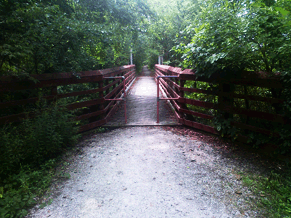
Bridge over the Portage River
MD Edmonds
Supervisor: Charles Huth
• 419-448-0007
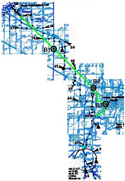
56.09 Total Miles / 24.16 Off Road Miles (43.1%)
Map Publication Date: March 2018
You've reached the flat farm land of Ohio where the major risk to hikers is falling into one of the deep drainage ditches along the road. The land here was shaped during the last ice age, leaving it flat and fertile. This section provides a pleasant, easy walk, ideal for lazy summer days or crisp autumn weekends. While following the many back roads you will experience the midwest country atmosphere close-up. The section begins in the small town of Waterville and passes north of Bowling Green before crossing I-75. From here, the trail turns northeast through farm land and alongside small streams and rivers, through the villages of Pemberville, Woodville and Elmore. At Elmore, the trail joins the North Coast Inland Trail (NCIT). The NCIT travels SE through more farm land and into the city of Fremont. Most notable in Freemont is the Rutherford B. Hayes Presidential Center. Leaving Freemont, the NCIT continues SE to the village of Clyde. At Clyde the Pemberville Section ends and the Norwalk Section begins.


Trail Alerts
- (11/18/24)The Ohio Turnpike and Infrastructure Commission completed their work in the Pemberville Section between Points 18 and 19 that affects the North Coast Inland Trail(NCIT) and the BT. The Commission removed its mainline bridge over the NCIT at milepost 83.3 on I 80/I 90, in Sandusky County. As a result of the bridge construction project, about a one‐quarter mile stretch of the NCIT that runs under the Ohio Turnpike near Waggoner Road in Washington Township closed May 2024, for relocation.
A new east‐west section of the trail will be built adjacent to the Ohio Turnpike to Waggoner Road. The new trail will continue south along Waggoner Road under the Ohio Turnpike and will reconnect back to the original trail on the south side of the Ohio Turnpike. All trail related work is expected to be completed in 2025.
The detour for the trail began earlier this year at the start of the bridge construction. Hikers and bike riders can follow the posted detour signs that will take you from Point 18 (CW) turning S on Schultz‐Portage Road 1.0 mi to Behring Road, E on Behring Rd. 1.0 mi, and then N on Waggoner Rd 125ft to the NCIT. Turn SE and continue on the trail to the Village of Lindsey.
Map Updates
- (2/6/2017) This update for the Pemberville Map Edition of March 2012 makes both a minor change to the descriptive material under Point 12 and announces a new campsite.
- NEW TEXT UNDER POINT 12: The new descriptive material is necessary because the Portage River Trail no longer ends at Front St. It now continues further north. Please replace the current text under Point 12 with:
Turn north onto the Portage River Trail, a paved walking/exercise trail that is owned and maintained by the Village of Pemberville. Continue north across Kesson Road (0.24 mile) into Pemberville and across the Portage River (0.24 mile). At Front Street (SR 105, 0.12 mile), leave the rail trail. Turn northeast onto the sidewalk along Front Street. - CAMPING: The new campsite is located off Sugar Ridge Road on property owned by the Black Swamp Conservancy. Specifically, it is behind their Office whose address is 4825 Sugar Ridge Road, Pemberville, OH 43450.
To make camping arrangements, contact the Conservancy by phone at (419) 833-1025 or by email at bsc@blackswamp.org at least a day in advance of arrival.
To reach the campsite from the west (clockwise), BTA recommends that you follow the marked trail to the intersection of Alexander Road with Kohring Road, 3.1 miles east of Point 11. Turn north onto Kohring Road until it ends at Scotch Ridge Road (0.35 miles). Turn west onto Scotch Ridge Road. At the first side road, Luckey Road, turn north. Continue north past Reese Road to Sugar Ridge Road (1.6 miles). At Sugar Ridge Road, turn east to the Office on the south side of the road (0.18 mile). The total distance from Alexander Road is 2.4 miles. While you may have been tempted to follow Sugar Ridge Road east from Point 6 because the distance to the campsite is much less (6.3 miles compared to 13.7 miles by the recommended route), know that traffic on Sugar Ridge Road is both moderately heavy and fast.
From the east (counter clockwise), head southwest from Point 13, which is located in downtown Pemberville, to the Portage River Trail (0.35 miles). Turn north onto the Portage River Trail across Perry St to the end of the trail at Reese Road (Parking).Turn west onto Reese Road and continue to the first crossroad (0.4 mile). Follow this road, Lemoyne Road, north for 1.0 mile to Sugar Ridge Road. Follow Sugar Ridge Road west for 0.8 mile to the Office. The total distance between Front Street and the Portage River Trail to the Office is 2.2 miles. However you reach the Office of the Black Swamp Conservancy, camp behind the Office near the fire ring at [41.42693 N, 83.48934 W].
To return to the trail, either retrace your steps or invert the routes to the Office that are described above.
- NEW TEXT UNDER POINT 12: The new descriptive material is necessary because the Portage River Trail no longer ends at Front St. It now continues further north. Please replace the current text under Point 12 with:
Trail Towns
- There are no Trailtowns in this Section at the present time.
Section Blogs
- (3/30/25) Pemberville Section Blog—Hike the Buckeye Trail between Elmore, Fremont, and Clyde: A Presidential Museum, Gorgeous Historic Homes, and Serene Landscapes Follow Victoria Livingston as she and husband Dave hike the North Coast Inland Trail from Elmore through Fremont and Clyde, Ohio. Visit a Presidential Museum and view historic mansions, serene landscapes, and colorful flowers along the trail. Afterward, dine at Pioneer Mill in Tiffin. Read her blog Here.
- (3/30/25) Pemberville Section Blog—Buckeye Trail: To Ignore or Go Forth at Detours Along the Route Victoria and Dave find another detour sign on the Buckeye Trail! Should we go around the sign or should we take the mile-long detour? What would you do? The trail between Lindsey and Elmore along the rail trail looks out on fields. Near Elmore, it is more scenic with a forest, covered bridge, and golf course. In Elmore, you will discover history by observing a log house and railway station. Read her blog Here.
- (3/30/25) Pemberville Section Blog—The Best of Pemberville: History, the Beauty of Nature, and Legendary Creatures The Buckeye Trail passes through Pemberville, Woodville, and Elmore, past war memorials, the scenic Portage River, Speedtrap Diner, Schedel Gardens, and four Bigfoot sightings. Read the blog written by Victoria Livingston Here.