Massillon Section
Trail Description

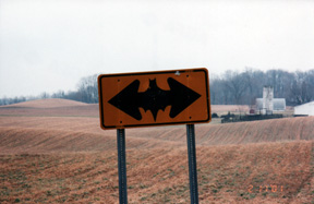
Sign in Massillon Section
Supervisor: Scott and Mary Anne Kamph
• 440-309-0919
53.6 Total Miles / 26 Off Road Miles (48.5%)
Map Publication Date: December 2020
The Massillon Section begins in Hartville where the Mogadore Section ends. The north end of the trail follows suburban roads through the City of Green and on past Nimisilla Reservoir, a unit of Portage Lakes State Park. In Crystal Springs, the trail connects to the south end of the Akron Section. This junction closes the ‘Little Loop’ of the Buckeye Trail, which comprises the Akron, Bedford, Burton and Mogadore Sections, as well as the part of the Massillon Section described above. Next, the trail joins the Congressman Ralph Regula Towpath Trail Park, a unit of Stark Parks. This trail is built, where possible, on the towpath of the old Ohio Erie Canal. The trail is followed through the remainder of Stark County and some of Tuscarawas County. The trail visits the towns of Massillon, Navarre and Bolivar. Towards the south end of Stark County is the transition between the glaciated plateau of northeast Ohio to the unglaciated plateau of southeast Ohio. However, after you cross the Tuscarawas River near Zoarville in Tuscarawas County, the change will become much more obvious. Here, the Buckeye Trail once again follows country roads past Camp Tuscazoar as they undulate and meander into the Bowerston Section.


Trail Alerts
- (1/15/24)Section Superviors, Scott and Mary Anne Kamph, report that between Points 7 and 8, the bridge over Nimisila Reservior on Christman Rd is now open. The bridge is located just N of the intersection of Christman and Comet Rds.
However, please note that the roadway is not marked yet, and hikers should be cautious when walking the berm. - (5/12/21) This alert reminds hikers that flooding conditions do occur after heavy rains. Please refer to the Starks Parks website for trail alerts that identify their trail closures, including for flooding.
Map Updates
- (8/24/2021) This Trail Change reports a small move in the physical location of the trail. However, the move has had a massive impact on the physical safety afforded to users of the BT and OECT. The change is located between Pt 20 W of Bolivar and 21 within Bolivar, specifically between the SW end of the trail bridge across the Tuscarawas R near McDonnell Trailhead and a little past the twin span RR overpass which allowed passage beneath for both SR 212 and the Ohio and Erie Canal.
The trail remains on the OECT which now bypasses McDonnell Trailhead and meanders E towards the RR overpass where it enters the canal prism on a boardwalk. Through the overpass, the canal heads away NE while OECT turns SE pretty much parallel to SR 212 but safely distant.
While the trail no longer goes through McDonnell Trailhead, the trailhead remains close and remains available for use.
One other change is important to backpackers. Just past the overpass, the trail now passes a commercial campground that offers only primitive campsites and no generators! It also appears to be available year around. See https://www.hipcamp.com/en-US/discover/ohio/towpath-trail-peace-park for details.
As if all that were not enough, the change in distance is so minor that it can be ignored here. - (8/15/17) Primitive camping (no facilities) is available on Tim Singer’s property on the west side of the Tuscarawas R at Point 19, only $5.00 per head. Because parking is limited, hikers wishing to basecamp from vehicles here have limited opportunity. Contact Tim Singer to confirm your desires. Although Singer did say that drop-ins would be accommodated, at least a day’s notice seems like common courtesy. Contact Tim at or 330-775-2198.
Trail Towns
ZOAR
Zoar was dedicated on May 13, 2016 at TrailFest. Zoar Village was founded in 1817 in Northern Tuscarawas County, Ohio near the Tuscarawas River by a group of 200 German Separatists seeking escape from religious persecution in their homeland. These Separatists thrived as a unique Society for more than 80 years, making Zoar Village one of the most successful communal settlements in American history. Today, Zoar Village is made up of approximately 75 families living in homes built from 1817 to the present.
The Buckeye Trail comes to Zoar past Ft. Laurens and using the Zoar Valley Trail, towpath trails, and a foot bridge leading into Zoar.
The North Country Trail, which runs concurrently with the Buckeye Trail through most of Ohio, does split off from the Buckeye Trail and heads east toward Pennsylvania. Cared should be taken not to follow the North Country Trail, as it is also blazed in a similar blue color.
Click on the following link for a listing of local lodging, dining, shopping, and attractions: Historic Zoar Village
Section Blogs
- There are no Blog posts at the present time.

