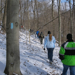


For nearly 1,400+ miles, the Buckeye Trail winds around Ohio, reaching into every corner of the state. From a beachhead on Lake Erie near Cleveland, to an hilltop overlooking the Ohio River in Cincinnati, a hiker can experience a little of all that Ohio has to offer.
First envisioned in the late 1950's as a trail from the Ohio River to Lake Erie, the Buckeye Trail evolved into a large loop, branching both north and east from Cincinnati. The separate legs rejoin in the Cuyahoga Valley National Park near Cleveland, and complete the trip to the lake. Because it is a loop, it is also in essence, endless. You may start a hike at any point and hike as long as you want without ever reaching an end!


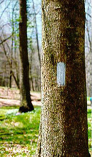
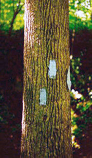
The trail is identified by blue blazes, 2" wide by 6" high, on trees or poles. A single blaze marks the trail where the route is fairly straight or obvious, while a double blaze marks a turn with the upper blaze offset to indicate the new direction. A double blaze with no offset simply means pay attention – the trail route may not be obvious.
The trail is maintained and managed by the Buckeye Trail Association, a private, non-profit volunteer organization. Use this site to help plan your Buckeye Trail adventure. Start with the overview map, then zoom in on a section of interest. Read the section close-ups, contact the section supervisors, and get the detailed maps for those areas that interest you. Check the events for a group hike, and finally, visit the online store to buy everything you will need.
Most important . . . find the time to explore Ohio up close and personal along the Buckeye Trail.