
Akron Section
- Overview
- Akron
- Bedford
- Belle Valley
- Bowerston
- Burton
- Caesar Creek
- Defiance
- Delphos
- Loveland
- Massillon
- Medina
- Mogadore
- New Straitsville
- Norwalk
- Old Man's Cave
- Pemberville
- Road Fork
- St. Marys
- Scioto Trail
- Shawnee
- Sinking Spring
- Stockport
- Troy
- West Union
- Whipple
- Williamsburg

Trail Description
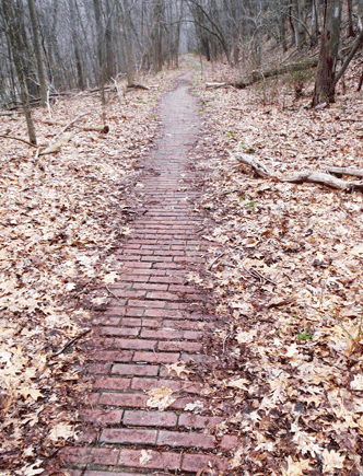
Brick walkway leading into Peninsula.
Andy Niekamp
Supervisor: Jim Sunny Sunyak
• 216-235-6057
57 Total Miles / 54.9 Off Road Miles (96.3%)
Map Publication Date: November 2021
Despite being one of the most populated sections of the Buckeye Trail, the Akron Section is quite remote. It is one of three sections in which the trail is largely off-road. Akron Section’s companions are Loveland Section and Troy Section of which all include urban centers. Resupply possibilities are never far away. Because so many services are available, the section map does not keep track of them.
Geologically, the Akron Section lies entirely within the expanse of the glaciated Allegheny plateau. In the northern half, the trail traverses highly dissected segments of the plateau. In this region, trail is either on the upper portion of the plateau or in lowlands, either of which may be quite flat. However, in the transition zones, expect about half of the altitude change to be steep, often up to 30%. In its dissected segments, expect significant climbs and descents with a maximum relief of about 120’. Even in the northern region, trail on the dissected plateau is interspersed with segments on or close to what remains from the towpath of the Ohio and Erie Canal. Since canals by their nature must stay near their source of water, expect trail on the towpath to be quite flat. That is not to say that the altitude of the towpath does not vary but the variation is slow and one directional. These segments become ever more frequent, and longer, as you go further south. Indeed, the whole southern half of the trail is on the Ohio and Erie Canal Towpath Trail.
The political divisions along the way are many. Beginning with the counties, the section begins in Cuyahoga County, traverses Summit County and ends in Stark County. Starting again from the north, the trail begins within the Brecksville City Limits within Brecksville Reservation, which is owned and managed by Cleveland Metroparks (CMP). Here, you are also within the legal confines of Cuyahoga Valley National Park (CVNP). Leaving Brecksville Reservation, you will enter property owned and managed by CVNP. A little later, you will traverse a property owned by Summit Metro Parks (SMP) and managed as a game preserve. Further south, you will pass through a population center in Boston Township, the Village of Peninsula, the ghost town of Ira, O’Neil Woods Metro Park (SMP) and the ghost town of Botzum. Shortly, you exit the legal boundary of the CVNP and cross the Akron City Limits. Soon, you enter Sand Run Metro Park (SMP) and the Cascade Valley Metro Park (SMP). Thereafter, you climb and cross the northern continental divide near downtown Akron. After leaving Akron, you enter the City of Barberton, cross a former superfund site and enter the smaller cities of Clinton and Canal Fulton. In Canal Fulton, you can purchase a ride on the St Helena III, a boat similar in size and shape to the original canal boat, and/or visit the Canal Fulton Heritage Society museum. This section ends a little further south in Crystal Springs where the Buckeye Trail enters the Massillon Section.


Trail Alerts
- (1/27/2024) This alert applies to W Bath Rd between Points 11 and 12. Hikers need to be aware of traffic conditions when exiting the Deer Run Trail in O'Neill Woods Metropark and turning E onto W Bath Rd to reach Point 12. The roadway and berm are narrow, vehicles may be close to the edge of the road, and drivers may not be expecting hikers. Wear bright colored clothing and stay alert. The BTA is supporting local residents to request warning signage to be placed along the road to help drivers become aware of hikers.
Map Updates
- (12/20/2024) This update at Point 13, Crosswalk at Riverview Rd at Smith Rd, comes from the Akron Section Supervisor. Camping is no longer authorized for any reason at the Greater Akron Motorcycle Club. Please do not contact the club for any camping information.
- (10/27/2024) This map update removes several trail alerts related to closures in Summit Metro Parks’ (SMP) Sand Run Metro Park, earlier this year from Point 13 to Point 15 in the Akron Section. Construction between these points permanently closed this section of Sand Run Parkway to vehicles to protect wildlife and allow for future trail connections. The work included removal of a culvert, placement of a pedestrian bridge, narrowing of the road to trail width, and removal of roadway elements. At Point 14, Summit Metro Parks relocated the BT and Parcours Trail to a new paved trail that was built on an old section of Sand Run Parkway from N Portage Path to Merriman Rd. In addition to the construction changes, this map update also addresses the change of names for various facilities and trails within Sand Run Metro Park. Mingo Lodge's name has changed to Chestnut Lodge. The Mingo Trail name has been changed to the Nuthatch Trail. The SMP BT Trail symbol has a blue B and is displayed throughout the entire route within Sand Run Metro Park. Follow the symbol. The following trail log addresses all those changes: PT 13. Crosswalk at Riverview Rd and Smith Rd. Cross Riverview Rd on crosswalk; continue W on Smith Rd for 400 ft. Just after crossing Cuyahoga Valley Scenic Railroad (CVSR) tracks, exit Smith Rd; turn S on footpath past Summit Metro Park’s marker with their BT Symbol into Sand Run Metro Park (a unit of SMP). After 0.11 mi, cross through the Chestnut Lodge parking oval and join the Nuthatch Trail (which also exits W) as it descends S on the paved driveway and joins the Parkway Jogging Trail going S to cross the Sand Run bridge. Immediately exit the driveway onto a footpath and head SW with the Nuthatch Trail into scrubby woods along Sand Run. After 350 ft, cross Sand Run Pkwy at crosswalk; turn SE up hill. After 50 ft, the Nuthatch Trail joins the Dogwood Trail, a loop trail; head E. After 0.4 mi, pass a short access trail to the Shadowfield Area (P, PT). After 600 ft, at the trailhead where the Nuthatch Trail ends, the Dogwood Trail heads W uphill, and the Valley Link Trail (VLT) heads generally S, join the VLT. After 300 ft near a Pr, follow the VLT SE across the Wadsworth Area (P, PT). After 400 ft, reach the southern end of parking row along Sand Run Pkwy in the Wadsworth Area; turn generally S. After 400 ft, continue on the VLT heading S. After 0.3 mi, ford a small stream. After 0.14 mi, pass by the Lone Spruce Area (P, Pr, PT, W). After 0.28 mi, pass Old Portage Shelter and continue through the Old Portage Area (250 ft, P, Pr, PT, W) a grassy area towards a parking area. At the edge of the parking area, turn E to reach the end of Sand Run Parkway at N Portage Path. Follow SMP BT and VLT symbols on posts and cross Sand Run Parkway N to rejoin the Parkway Jogging Trail. PT 14 Valley Link Trail (VLT) at N Portage Path. Turn E and use the crosswalk on the VLT to cross N Portage Path and immediately cross the pedestrian bridge. Follow VLT for 0.5 mi. Continue NE on the VLT, cross Merriman Rd at crosswalk, and in 250' descend steps into bottom land to cross CVSR RR tracks to the Ohio & Erie Canal Towpath Trail (OECTT). PT 15 Valley Link Trail (VLT) at Ohio & Erie Canal Towpath Trail (OECTT).
- (2/24/2024) Just east of Point 5 in the Akron Section, the National Park Service (NPS) has opened a new pedestrian bridge for crossing the Cuyahoga River. This changes the description of the trail at Point 5 and updates the Akron map edition of November 2021. The description is as follows:
5. Footpath at Riverview Rd Near Boston Mills Rd Continue straight (NE) across Riverview RD and follow the paved footpath to the National Park Service Visitors' Center. After crossing the RR tracks, turn slightly right (SE) to cross the new pedestrian bridge over the Cuyahoga River. Follow the marked yellow path through the cul-de-sac to Ohio Erie Canal Towpath Trail (OECTT). Turn right (SE) onto OECTT. At the request of the NPS the OECTT is not blue blazed; please see NPS posts on OECTT for directions. Continue to follow the OECTT as it generally goes along the right bank of the Cuyahoga R, as described in the remainder of the Point 5 description. - (1/4/2022) Akron Supervisor, Sunny Sunyak, and his team have worked to eliminate a wet part of the trail in the Akron Section near Ottawa Point between Points 1 and 2. This wet trail was located just prior to where the trail exits to Ottawa Point Parkway. The change to the hiker will be hardly noticeable as the trail is only changed for a short distance - about 700’ in length, less than 30’ from the old trail for 300’, and 90’ at the furthest location from the old trail. This effort adds a negligible amount to the trail in total.
- (11/30/2021) A new Akron map has now been published and is available to order from the Buckeye Trail store.
- (4/25/2021) This update comes from the National Park Service through the Akron Section Supervisor. Camping is no longer authorized for any reason at The Spicy Lamb Farm. Please do not contact the Farm for any camping information.
- (2/27/2020) Edition of January 2012 - Pt 5, paragraph 2 identifies camping near the Stanford House. However, this privilege has been withdrawn. The campsites near the Stanford House have been removed. To update your map, delete paragraph 2 from the text completely and remove the image of the tent that is shown a little N of Pt 5 from the graphic.
- (7/12/2019) Camping is available between Points 1 and 2 in the Akron Section. Backcountry camp sites are located near the Ottawa Point Picnic Area. Obtain your free required permit from Cleveland Metroparks. Call 216.635.3304 to reserve a backcountry site. Allow at least 2 weeks advance notice. Sites are available from the Memorial Day weekend through the last weekend in September. Additional information and restrictions can be found at: https://www.clevelandmetroparks.com/parks/visit/activities/event-activity-types/backpacking#permit
- (6/28/2019) This change to the route of the BT near the Botzum Trailhead of the Ohio & Erie Towpath Trail (OETT) was precipitated recently when a contractor placed his office trailer squarely across the entrance to a short segment of trail just past Pt 12 (Bath Rd at Riverview Rd). This segment had been built on the original heelpath and towpath of the canal. This segment had already come to the attention of Sunny Sunyak, the Akron Section Supervisor, because of maintenance problems caused by frequent flooding of the trail at a low point where the trail crossed the canal prism from the heelpath to the towpath. In consultation with the Map Team, Sunyak decided it best to move the trail from Bath Rd onto the OETT at a location that comes immediately after Bath Rd crosses the Cuyahoga Valley Scenic Railroad (CVSR) and somewhat before its intersection with Riverview Rd.
The change barely affects a hiker. The distance remains unchanged. Pt 12 has been moved to the intersection of OETT with Riverview Rd, the map text has changed. See the important features of the result below.CW CCW Pt 22.4
W35.2
E11 Lone Pine Area in O'Neill Woods
Facilities: P, Pr, PT. The current text remains unchanged until the last sentence. Substitute the following:
Leave O'Neill Woods and head SE on Bath Rd past Yellow Creek Rd (0.3 mi, exits W) and then across CVSR (0.26 mi). Soon (150'), exit Bath Rd S onto the OETT that will pass between 2 tree-covered mounds. The smaller one will be easily visible to your S. The larger one will lie to your W across the RR. After 0.2 mi, OETT reaches a 4 way intersection with paths from the Botzum stop on the CVSR just W and the large parking area of the Botzum Trailhead just S. (Other facilities: Pr, PT.) OETT continues SE.24.4
E33.2
W12 OETT at Riverview Rd
Facilities: P, Pr, PT. The current text remains unchanged until the last sentence. Substitute the following:
Across Riverview Rd, continue S now on OETT that continues around outer fence of the Akron Composting Plant and on S between the Cuyahoga R and the sewer line which lies in the former canal bed. After 1.4 mi, BT leaves OETT W through a square concrete culvert.25.9
W31.7
E13 Riverview Rd at Smith Rd
Resume use of the current Akron section edition of January 2012 - (10/5/2017) At Point 13 - The Greater Akron Motorcycle Club allows hikers to camp south of the pond on their property on the SW corner of this intersection. Get advance permission by sending an email to BOTH Rich Robinson at gamcrr@neo.rr.com AND Pat Tenny at gamcpat@yahoo.com. If questioned about permission when camping, provide Rich Robinson at (330) 760-3715 and Pat Tenny at (330) 524-2592 as the contacts.
- (5/16/2017) When reviewing material for the newest Akron Section Map, we missed the small campsite located within Big Bend Metropark. The campsite is small but only about 350' off the trail. See Pt 15 below. BTA significantly altered the route of the Buckeye Trail through Akron over the past several years. The traditional route had followed sidewalks on city streets between Sand Run Metropark and the intersection of Manchester Road with the Ohio Erie Canal Towpath. Beginning with the November 2005 Edition, the Buckeye Trail returned to the Ohio Erie Canal Towpath Trail from Sand Run Metropark and continued south on the Towpath Trail to North Street near the restored Mustill Store. The trail then followed North St, Maple St and Perkins Park Rd to return to the traditional route at the intersection of Perkins Park Rd at East Ave. Beginning with the January 2010 Edition, the Buckeye Trail has been extended to include Ohio Erie Canal Towpath Trail south from North Street through Goodrich on across Summit Lake to Manchester Road. Since many hikers have bought the November 2005 Edition, the text from the last 17 points of the present Akron map are presented as part of this Trail Alert.
| CW | CCW | Pt | |
|---|---|---|---|
| 27.8 E |
29.9 W |
14 | Sand Run Pkwy at N Portage Path Located 1/4 mi N along Portage Path at intersection with Merriman Rd, a marker honors the N end of the Indian Portage Trail (G, R) between the Cuyahoga R and Tuscarawas R. BT heads E on Sand Run Pkwy. In 150', BT jogs S across Sand Run onto the Valley Link Trail (VLT). In 260', VLT joins the Parcourse Trail (PT) heading E. Lying at the bottom of a ridge through mature forest, segment generally parallels Sand Run Pkwy. In 2100' as PT climbs SE, VLT continues NE across Merriman Rd (240') into bottom land. |
| 28.4 S |
29.3 W |
15 | Valley Link Trail at OECTT BT merges onto OECTT and heads S. In 1050', BT reaches the access trail to Big Bend Metropark (C, P). Located just 350' west on a bench a tad east of latrines, campsite (coordinates: 41.127872°N, 81.539512°W) is designed for through hikers or bikers. The specific rules for use are the same as those written under Pt 26, below. OECTT meanders S more-or-less parallel to the former towpath. The concrete sewer line nearby is built mostly in the canal bed. In 4600', BT reaches a view point at the confluence of the Cuyahoga R and Little Cuyahoga R. Between this point and Summit Lake, the canal followed route of short portage used by Indians during wet seasons. BT continues to meander along OECTT through this wooded, former dump site. |
| 30.6 S |
27.1 N |
16 | OECTT at Memorial Pkwy (P, WC) OECTT continues S often on former towpath and always on canal rights-of-way through remains of Lock 18 (1400'), past remains of Lock 17 (1300') and Lock 16 (2000'). In just 390', a little past an emergency access (formerly N Maple St), OECTT passes remains of former canal wasteway. In 430' in front of the Mustill Store Visitor Center (P, WC), step up to the remains of Lock 15 on your E. Look for the large turtles that sun themselves on the rocks in the pool below the lock. This lock is built upon rock. Most "float" on a wooden pediment in the clay and sands of the wet areas in which the canal was built. The reconstructed Mustill Store Visitor Center, is owned and operated by Cascade Locks Park Assn. |
| 31.7 E |
26.0 N |
17 | OECTT at North St (P) Continuing S on OECTT, BT climbs past the remains of 5 locks, the Beech St TH (P) and two RR trestles before the canal disappears beneath a complex of highways, all in the next 4500'. In 2200', BT has navigated generally S across these same highways and follows OECTT along widened sidewalks that border Quaker St, W Bowery St and Water St. |
| 32.8 S |
24.9 NW |
18 | OECTT at S End of Lock 1 Park BT turns S on OECTT along canal. Soon, OECTT turns E away from canal, goes beneath W Exchange St, turns back towards canal, goes beneath W Cedar St and then follows canal. In 2000' behind Spaghetti Warehouse, OECTT heads SW onto paved parking area near canal and continues through former Goodrich buildings (940') and Courtyard. BT exits courtyard through gate, crosses Bartges St (1200') at Locktender Drive and turns W on sidewalk. |
| 33.7 S |
24.0 E |
19 | Bartges St at OECTT BT turns S onto asphalt path on W side of canal into a part of Canal Park that is surrounded by residential properties. In 2200', OECTT and canal go beneath Thornton St bridge, turn W across Dart Ave (300'), turn S beneath SR-59, cross canal (450') and finally head SW beneath the I-76 and I-77 complex (1600'). |
| 34.8 S |
22.9 N |
20 | Trailhead near Summit Lake Recreation Center Boat Launch, Fishing Pier, P) Summit Lake (El 964') was a natural glacial, pothole lake. Engineers dropped its level 9' when they made it part of the Ohio Erie Canal. The lake received its name as the highest point along the canal. BT goes S along Summit Lake. In 1600', OECTT moves onto a 1400' floating bridge reminiscent of the floating towpath that existed here in canal days. While the old towpath sank as the mules and mule tenders moved along, this is a dry boot trail. |
| 36.5 SE |
21.2 NW |
21 | Access to Wilbeth Rd Trailhead (P, Pr, W) BT goes S on OECTT. In 2800', trail crosses a bridge over a waterway that extends SE as canal turns SW. In the early days of the canal, the waters of the Tuscarawas R fed directly into the canal somewhere along this swampy area. Perhaps this is the location. Because the river failed to provide a steady supply of water, a system of reservoirs named Portage Lakes was constructed to water the canal. Long Lake was the final link in that system of reservoirs. Just W of Manchester Rd Bridge, water from Long Lake emerges from a culvert beneath the TP into the canal, a condition that makes this point the present summit of the Ohio Erie Canal. |
| 38.2 W |
19.5 E |
22 | Access to Manchester Rd Trailhead (P) This site is near the information kiosk. BT follows OECTT W past active brine sites, under an overpass that carries the Akron & Barberton Beltline RR, past the reconstructed culvert at Mud Run and finally beneath State St Bridge. There is no access between BT and State St. |
| 40.8 SW |
16.9 NE |
23 | BT at Fairview Ave. At the intersection of Fairview and Wooster Ave 1/4 mile W of here, a statue honors Hopocan, a Delaware chief. In 1650, Chief Hopocan ruled New Portage as Barberton was then known. BT continues W on OECTT passing the site of former Tuscarawas Ave bridge (5200'). Ahead, a modern bridge pretty much obliterates another old bridge site (Robinson St). Further on (1700'), BT crosses a concrete slab over a decaying wasteway. In 360', BT passes a house whose occupants may use towpath for their vehicles. In 1200' at the end of the watered canal are the only visible remains of Lock 1S. The ghost town of Wolf Creek is in the space that is occupied by Wolf Creek TH (P, WCs) SW of Lock 1S. BT continues W on Wolf Ave and turns E onto Snyder Ave (450'). |
| 42.9 S |
14.8 W |
24 | Snyder Ave at Van Buren Rd BT turns S on Van Buren Ave. At Elson Ave (2200'), Avilee Webb Park (P, Pr) is 1/2 block E. In 3000' at Eastern Rd, BT jogs W onto OECTT and continues S parallel to Van Buren Ave across Tuscarawas R. (1100'), past a view of a neat reclaimed pond within the fenced tailings area (350') and past a sewage plant (1200'). PPG Industries is reclaiming this extensive region of "lime lakes" along the Tuscarawas R by mixing the tailings with treated sludge from this sewage plant. Over time, this mixture creates a healthy ecosystem from the formerly sterile landscape. OECTT climbs a low hill and descends now parallel to Vanderhoof Rd. and soon enters the Vanderhoof Rd TH (2800', P, Pr). |
| 45.0 S |
12.7 SE |
25 | OECTT at Vanderhoof Rd Although this location is close to the route of the Ohio Erie Canal, no tangible evidence for its existence is visible. BT joins OECTT that heads S only a few feet E of the nearby Chessie RR. OECTT crosses 3 extended bridges over the next 2900'. About 630' past third bridge, OECTT turns away from the RR. Almost immediately, a canal prism appears. The trail continues S on the towpath. |
| 47.2 SW |
10.5 NE |
26 | OECTT at Center Rd and TH (P, Pr, PT) BT continues SW on OECTT and soon crosses Pancake Creek (1100'). In 400', BT passes short spur trail to 3 tent sites (Pr, PT, W). Sites are free and may be used by through backpackers and bike packers only. Each site may be occupied by up to 4 people on a "First come, first served" basis. No reservations. No open fires. Cook over camp stove. Carry out all trash. Use "minimum impact" techniques. In 3200', BT reaches remains of Lock 2. A plaque provides details of area. BT descends from lock and crosses two bridges, the second of which crosses remains of wasteway (350'). In 190', BT reaches remains of Lock 3. BT crosses bridge built on lock walls over former canal and continues SW. Another plaque offers interesting commentary on the canal to the north. Just south of the lock site, notice the lack of a berm on the far side of the canal prism. This spot marks where the Tuscarawas R joined the canal for a short distance. As you proceed S, look for stones at the edge of the canal. Here the river exited the canal. The stones hardened the fill. Across bridge on the other side of the Tuscarawas R lie the remains of the Clinton Guard Lock. See plaque for details as well as interesting map that shows how the canal crossed the Tuscarawas R. |
| 48.7 S |
9.0 N |
27 | OECTT at North St in Clinton (Clinton TH) BT continues S on paved OECTT past bar and restaurant at Main St. BT continues S on OECTT with remains of canal to E and City Park (PT) to the W. In 1 mi, BT enters Stark Cty from Summit Cty and OECTT surface changes from asphalt paved 10' wide to chipped limestone, 8' wide. In 400', BT passes site of former Blue Goose Saloon. The saloon was an infamous watering hole during canal days. In 2 mi, canal receives water from operating Nimisila feeder. |
| 52.5 SE |
5.2 NW |
28 | OECTT at Market St in Canal Fulton Village of Canal Fulton, NE on Market St 1 block, then SE on Canal St, offers a variety of services including Gallery, sweet shops, restaurants and PO 44614. There is a bridge back across canal 1 block SE of Cherry St allowing easy return to OECTT if you choose to dally. OECTT heads S on boardwalk past Kilbride Park and custard stand on W. OECTT continues S from Cherry St past Canal Fulton Heritage Society Museum with canal memorabilia (P). In 500', OECTT goes behind Canalway Centers or Port of Canal Fulton (P, Pr) where tickets may be bought in season to ride on the St Helena III, a canal boat replica w/ concrete hull, in season. BT continues SE on TP past dry dock for St Helena III. |
| 53.6 SE |
4.1 NW |
29 | Lock 4 Park (P, Pr, PT) This Stark County Park features a restored lock and tumble in a picturesque setting. BT continues SE on OECTT. |
| 54.9 SE |
2.8 NW |
30 | OECTT at Butterbridge Rd (T-358) BT continues SE on OECTT. In 2.5 mi at 3-Way Trail Junction, Trail Bridge offers access to Crystal Springs Park w/hiking trail, P, Pr, PT. BT now heads SW on OECTT and, in 260', crosses a reconstructed culvert that may be worth a look. |
| 57.7 E |
0.0 W |
31 | OECTT at High Mill Rd (T-352) in Crystal Springs (R) Two restaurants lie within 1/4 mile E on Erie Ave. This is also the S end of the Little Loop of BT. In CW order, Little Loop comprises the AKRON, BEDFORD, BURTON and MOGADORE SECTIONS as well as the Hartville to Crystal Springs segment of MASSILLON SECTION. The AKRON SECTION ends here. BT description continues in the MASSILLON SECTION, whether you are traveling S to Cincinnati or N to Lake Erie. |
Trail Towns
- There are no Trailtowns in this Section at the present time.
Section Blogs
- (6/9/24) Akron Section Blog - The Buckeye Trail traverses Akron's revitalized downtown, featuring Ohio and Erie canal paths, waterways, murals, art of empowered women, and welcoming parks. Provided by Victoria Livingston, BTA hiker. Join Victoria and her husband Dave as they hike through downtown Akron.
- (5/21/23) Akron Section Blog - Provided by Victoria Livingston, BTA hiker. Join Victoria, her husband Dave, and other family members who joined her at Deep Lock Quarry Metro Park. Follow their adventure here on the rainy BT that day. .