
Williamsburg Section
- Overview
- Akron
- Bedford
- Belle Valley
- Bowerston
- Burton
- Caesar Creek
- Defiance
- Delphos
- Loveland
- Massillon
- Medina
- Mogadore
- New Straitsville
- Norwalk
- Old Man's Cave
- Pemberville
- Road Fork
- St. Marys
- Scioto Trail
- Shawnee
- Sinking Spring
- Stockport
- Troy
- West Union
- Whipple
- Williamsburg

Trail Description
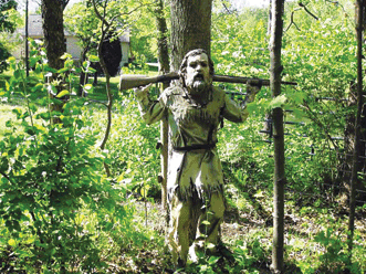
Carving on the trail near East Fork.
Chris McIntyre
Supervisor: John Davidson
•
52.6 Total Miles / 25.2 Off Road Miles (47.9%)
Map Publication Date: March 2024
This section starts along Grant Lake, and follows narrow country roads past numerous farms for about nine miles. After passing just southeast of the City of Williamsburg, the trail winds 23.5 miles through East Fork State Park, which is almost entirely off-road. The BT utilizes the Steve Newman Worldwalker Perimeter Trail, which provides challenging hills and beautiful views and scenery. The western part of the section finds increasing urban evidence as the trail nears Cincinnati. It passes through the city of Batavia, and along some more heavily traveled roads, before ending in Milford, where it joins the Loveland Section and the Little Miami Rail Trail.
Note: Consult with the East Fork State Park website for the latest alerts concerning trail closures, water levels, public hunting information, and campsite notices.


Trail Alerts
- (5/13/25) Hiking Guidance in East Fork State Park Based on Lake Levels
Williamsburg Section Supervisor, John Davidson, replaces an alert dated 4/22/25 that concerned flooding in the East Fork State Park area. John reminds hikers that flooding occurs in areas along the BT in East Fork State Park, especially between Pts 12 and 18 and not always in the spring. The detour is from Pts 8 to 21. He offers additional information that may help hikers determine if they should use the alternative Dry Boot Trail that follows the Williamsburg to Batavia Hike‐Bike Trail (WBHBT) on the north side of William H. Harsha Reservoir. Using the WBHBT reduces the length of the Williamsburg section by 18.2 mi.
Normal Levels: 729 ft (Winter Pool) — 733 ft (Summer Pool)
Current Lake Level can be checked here.
Guidance for Thru-Hikers (Williamsburg Section):
Lake Level is approaching 740 ft, or if 2 or more inches of rain are forecasted or have recently fallen. Use the alternate Williamsburg to Batavia Hike/Bike Trail due to potential flooding along the Buckeye Trail.
The alternate can also flood if the Lake Level is over 765 ft (Years noted: 2011, 2005):
Impassable Area:— Lowlands near the Bike Path Lookout on the Alternate Williamsburg to Batavia Hike/Bike Trail.
Guidance for Section Hikers:
Lake Level Approaching 740 ft
Impassable Area: — Low areas around Camp 3, between Williamsburg Points 13‐14 (Near Perimeter Trail mile marker 11)
Lake Level Over 740 ft
Impassable Areas: — Clover Lick Creek, Between Williamsburg Points 13‐14 (Perimeter Trail mile markers 10–11)
— Poplar Creek, Between Williamsburg Points 14‐15 (Near Perimeter Trail mile marker 6)
— Low areas around Camp 2 and along Backpack Trail, between Williamsburg Points 15‐16
Lake Level Over 750 ft (Years noted: 2025, 2018, 2011, 2005, 1979)
Impassable Area:
— Ulrey Creek, Between Williamsburg Points 17‐18 (Perimeter Trail mile markers 32–33)
See the log below for the Williamsburg to Batavia Hike‐Bike Trail Alternative — Dry Boot Trail:
CW CCW Pt 0.0
NW12.1
E8 Todd’s Run-Foster Rd. (T-90) at SR-I33
Todds Run-Foster Rd ends here. Head NW (right) on SR-133. Soon, enter Williamsburg. After 0.35 mi, join Main St. Along with SR-133, turn W (left) onto bike/pedestrian path. Continue on Main St past entrance to Williamsburg City Park on SW (P, PS, PT, W, WC) and Dela Palma Rd on NE (0.3 mi). Continue on across the East Fork of Little Miami R into downtown Williamsburg (G, R, P0: 45176). After 0.45 mi, turn SW (left) onto S Broadway St and continue for 4 blocks to the Williamsburg to Batavia Hike-Bike Trail (WBHBT).1.5
W10.6
NEA S Broadway St at Williamsburg Batavia Bike Trail (WBHBT)
The trail enters WBHBT, marked by green Bike Route signs. After 0.26 mi, the bike path joins Williamsburg Bantam Rd, heading generally SW (left).3.5
W8.6
EB Cain Run Bridge on WBHBT
WBHBT meanders some as it heads generally W past a view of the East Fork. WBBT turns generally NW from here. After 0.6 mi, WBHBT joins the central road within East Fork State Park Campground and continues NW (right) past the entrance to Camp Loop D (0.17 mi, exits S).5.4
N6.7
SC Central Drive within East Fork State Park Campground at Entrance Station
Continue N on the central drive within the park campground. After 0.4 mi, the campground road ends. Join the Park Entrance Road, turning S (left) towards a boat launch.7.4
W4.7
ED Park Entrance Road at Dedicated Bike Trail
After 0.9 mi, exit Park Entrance Road and head W (right) on dedicated WBHBT. After 0.7 mi, exit park through gateway at end of Zagar Rd. Follow Zagar Rd briefly as it turns W. After 250', exit Zagar Rd and go ahead W on trail built over Old Summit Rd.7.9
S4.2
EE Old Summit Rd at Greenbrier Rd
At Greenbrier Rd, turn S (left) onto road and meander downslope generally SW. After 2.0 mi, join Elk Lick Rd and route of blue-blazed BT. Continue generally W (right) on Elk Lick Rd.12.1
N0.0
E21 Elk Lick Rd at SR 222
Return to your current Williamsburg map, Edition of November 2012. - (10/28/21) Hikers are encouraged to stay on Twin Bridges Road between points 9 and 10 due to the very muddy conditions that exist due to poor trail and horse use.
Map Updates
- (4/16/2024) A recent hiker brought to our attention an issue with the FarOut app. Near Williamsburg Point 13, there is a symbol for a camping shelter north of primitive camping area #3. This shelter does not exist anymore. Primitive camping area #3 does have a fire ring, benches, and space for a tent. If you read the text that goes with the description of that shelter symbol, you will see that there are shelters at primitive camping areas #1, and #2.
- (4/7/2024)The BTA Map Committee announces that an updated map is now available for the Williamsburg Section. This becomes the March 2024 edition and inlcudes the updates referenced below. The new map is available through the BTA Store.
- (11/5/2023)A new re-route of the BT has taken the trail off a portion of the dangerous Round Bottom Rd in Milford. The re-route changes the trail between Pt 28 and Pt 30. The change increases the length of the Williamsburg Section by 0.3 mi, all off-road. See the log below for details.
CW CCW Pt 46.6
SW5.7
NE27 Binning Rd at Round Bottom Rd
Binning Rd ends here. Perintown MM (MM w/G, ice cream, kerosene) is N across the East Fork on Round Bottom Rd. Head W on Round Bottom Rd that parallels Cincinnati District RR Line tracks (currently operated by Cincinnati Eastern RR) sometimes on the N and sometimes on the S. You will pass Tealtown Rd (0.35 mi, T123, exits S), Barg-Salt Run Rd (0.3 mi, T211, exits S), and go beneath I-275 overpass (1.5 mi). At Beechwood Rd turn right, N, and enter the city of Milford, on the east side of Beechwood Rd. At the roundabout, cross Chamber Dr, turn left (W), and follow the verge along the N side of the road to the second stoplight. Turn left (N) at the crosswalk to cross Chamber Dr at Milford Parkway. Continue along the W side of the road. Cross a vehicle bridge over the East Fork of the Little Miami River. (NOTE: Milford Pkwy is a busy road and drivers may not be accustomed to pedestrians.)50.0
W2.3
S28 Milford Pkwy at Finley Ray Dr (39.16628, -84.27653)
At Finley Ray Dr, BT turns left (W) into Finley Ray Park. At the first intersection, turn left (S) onto a gravel road/parking lot along the power line. At the picnic shelter, turn right (W) along the foul line fence of baseball field 5 Continue along to the outfield fence of baseball field 6. Continue across the urban footbridge into Valley View Foundation property. Turn left (S) onto a mowed path.
Continue generally S/W 0.52mi and reach the fence at the edge of Valley View Foundation property. Here, turn right (W) and follow along fence. In 350’ cross old road and continue on another 0.5 mi as it meanders W, NW, and then mostly N, until it reaches Milford Rd/Cleveland Ave at (39.165178N, 84.291740W).
Turn right (NE) onto Cleveland Ave. In 150', you will be heading N. Continue N across Hickory St (0.16 mi). After 1 block (0.13 mi), cross and turn right (E) onto Oak St. After one block (400'), turn left (N) onto Laurel Ave. At the end of Laurel Ave, cross Mill St and Garfield Ave. Turn left (W) onto Garfield Ave. After 0.18 mi, cross and turn right (N) on High St. After 1 block (400'), turn left (W) onto Elm St.
After 1 block (150'), turn left (S) on Main St (US 50) past “Roads, Rivers and Trails”, a trail-friendly outfitter who sells BT Section Maps, and cross Garfield Ave (400'). After another block (330'), turn right (W) along US 50 across Water St and on across Little Miami R. Follow blazes for safest road crossings. After crossing SR 126, go W uphill on paved trail into trailhead for Little Miami State Scenic Trail.52.3N/S 0.0
E29 Little Miami State Scenic Trail
The WILLIAMSBURG SECTION ends here. BT description either N or S is continued in the LOVELAND SECTION - (11/5/2023) Point 29 - Camping available in Milford in nearby Jim Terrell Park and Riverside II Park requires a new permit and has a fee. This is the link to the Parks and Recreation Department's web site with the link to the updated permit. See https://www.milfordohio.org/departments/public_works_department/parks_and_recreation/.
Section Blogs
- (11/6/23) Willimasburg Section Blog - Provided by Victoria Livingston, BTA hiker. The Buckeye Trail winds through scenic East Fork State Park but beware of the water crossings. It’s like a game of Frogger--leap, splat! This was a leap of faith at East Fork Lake for Victoria.