
Road Fork Section
- Overview
- Akron
- Bedford
- Belle Valley
- Bowerston
- Burton
- Caesar Creek
- Defiance
- Delphos
- Loveland
- Massillon
- Medina
- Mogadore
- New Straitsville
- Norwalk
- Old Man's Cave
- Pemberville
- Road Fork
- St. Marys
- Scioto Trail
- Shawnee
- Sinking Spring
- Stockport
- Troy
- West Union
- Whipple
- Williamsburg

Trail Description
Andrew Bashaw
Supervisor: OPEN
•
61.8 Total Miles / 24.2 Off Road Miles (39.2%)
Map Publication Date: November 2020
The Road Fork Section is one of the least populated sections along the Buckeye Trail. The extraction industries dominate industrial activity. The section lies entirely within the unglaciated, highly dissected Appalachian Plateau. The trail undulates somewhat over 12,400ft along its length within this section.
The section begins in Belle Valley, a village of 223 souls according to the 2010 census, which lies within Noble County. Belle Valley is the only incorporated community that you will go through along the section’s entire route. Most of the limited facilities that you will find in this section are here in Belle Valley. The section ends at a dirt road on a lonesome, wooded ridge in Washington County.

Trail Alerts
- (11/24/2024)
This alert provides an improved detour to address an issue in a former alert dated 9-10-2024. Tom Rohr had reported a warning about a hazardous culvert crossing between Pts 2 and 3. At the very end of the description of Pt 2, you are directed to exit Caldwell Lake Rd onto a footpath. About midway through the 1 mile footpath, after a lengthy downhill (CW) slope, the trail passes by a culvert running under Caldwell Lake Road that required a hazardous stream crossing adjacent to the culvert. This area continues to deteriorate. The trail has been rerouted a bit to correct the situation. After the lengthy downhill (CW) slope, the trail now continues onto Caldwell Lake Road and turns R (SE) on Caldwell Lake Road for about 30 yards and crosses above the culvert. It then turns right onto a new, relatively flat trail that runs for about 150 yards and connects to the existing trail. This route provides a much safer path with little change in distance.
- (7/13/2023)
It has been brought to our attention that the Road Fork Baptist Church on SR 260 and mentioned in Point 11, has burned to the ground. A wooden sign still stands, but who knows for how long. Since the church was used as an identifier in the text with mileage from the turn onto SR260, be aware that the building does not exist. The cemetery and small parking area remain.
- (3/2/2023)
Please note from Point 13 to Point 14 in the Road Fork Section that the local land owner along county road 78 does not permit hikers to camp, use their trash can or property as a picnic area, park, nor use the privately owned privy. Any possible infringement of their property rights can and will result in a call to the Monroe County Sheriff's Office. Avoid this inconvenience by not trespassing on this, or any other private property.
Map Updates
- (3/13/2025)
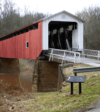
This map update moves the BT in the Road Fork Section back onto BT former trail that was abandoned over 15 years ago when the Knowlton Covered Bridge was closed. It eventually collapsed and a rebuild was completed this year. Part of the restoration included the use of beams with graffiti from the original bridge. Last year the trail crew and other volunteer groups cleaned and groomed the old trail. The update eliminates 3.7 miles of some tedious and uninspiring on-road walking and avoids floodplain needing recurring vegetation control. The update affects from Point 20 to Point 23. Points 21 and 22 were relocated.
Also with this reroute, several day-hike loops are possible using lightly traveled township roads and the Forest Service Spur Trail. Parking and porta potties are available at the Knowlton Covered Bridge. There is parking at Ring Mill Campground.
This update applies to the 2020 edition of the Road Fork printed map and to the Spring 2024 editions of the Avenza and FarOut Apps.
Note: Please subtract 3.7 miles from CW distance at each point from 23 and higher. And subtract 3.7 miles to CCW distance from Point 20 and lower. The log below has the correct miles:
CW CCW Pt 38.4
S23.4
W20 End of Witten Creek Rd (C15) at SR26
Turn SW onto SR26. After .4 mi. turn left onto (T384A). At this point there is a large sign signifying this direction to the Knowlton Covered Bridge Park (P, Pp). Follow this road across the bridge to the intersection with Old Camp Road. The Knowlton Covered Bridge was built in 1860. It gained national recognition in 1980 by earning a spot on the National Historic Places list. But age and decay caught up with the structure in 2019 when it failed and collapsed. It was rebuilt, using 19th century construction techniques and retaining some of the original beams, in 2023/24 for pedestrian and occasional light vehicular traffic.39.2
S22.6
N21 End of (T384) at Old Camp Road
Continue south for just a few yards on Old Camp Road (T88), then on the left, join a gated trail into the Wayne National Forest. The trail climbs, while overlooking the hamlet of Rinard Mills, 350 ft in .6 mi. to the top of Bell Hill. The trail follows the top of the ridge and then intersects the National Forest Spur Trail to Ring Mill campground. This spur trail heads north and then east about 3 miles to the Ring Mill Campground, which features canoe access to Little Muskingum River and the stabilized remains of the Ring House (no entry to structure). Camping sites are available at $10 per night. There is no potable water or electric power available.40.6
S21.1
N22 Three Way Intersection
The Buckeye Trail continues SE. After .04 mi at a 3-way intersection of woods roads, turn sharply NNE and continue along ridge. In 400’ at a 3-way intersection, the woods road continues E. Exit the woods road onto an old road that descends gradually. After 0.2 mi as the old road continues NE, join a footpath that undulates and meanders generally S across Road 98 (0.45 mi, T98). Continue to meander and undulate generally S through early succession woodlands.42.3 19.4 23 Footpath at Road 99 (T99)
. - (6/6/2023)
This map update, for the Roadfork map dated November 2020, affects both the Road Fork Section between Pts 29 and 30 and also the Archers Fork Loop Trail (AFLT). This trail change replaces a relatively uninviting path on an old oil and gas well service road. The reroute was accomplished with assistance from the River Valley Mountain Bike Association; a Wayne National Forest Marietta Unit work crew; and BTA members Tom Rohr, Russ Flesher, and Richard Lutz. Please note that the route is concurrent with AFLT mountain bikers and is flagged both blue (for BT) and yellow (for AFLT). Use appropriate caution.
This update adds an additional mile from Point 29 to Point 30. Please add 1 mi to CW distance at each point 30 to 31 and add 1 mi to CCW distance at each point 29 through 1. As a result, the total mileage for the Road Fork Section becomes 64.7 mi.
The following describes the new route:- Pt 29. Footpath at Upper Archer’s Fork Rd (T34) CW 59.3 CCW 5.4
- Cross Upper Archer's Fork Rd (SE).
- In 0.36 mi,the trail joins the new segment of trail to the left (slightly NW) which meanders another 2.2 mi through a wooded valley until it turns right (S) and in 40’ reaches Bell Cemetery Rd (T421).
- Pt 30. 4-Way Junction of Bell Cemetery Rd, AFLT, and Footpath CW 61.9 CCW 2.8
- Continue on as described on the 2020 map.
- Pt 31. Footpath at County Rd Nine (C9) CW 64.7 CCW 0.0
- Pt 29. Footpath at Upper Archer’s Fork Rd (T34) CW 59.3 CCW 5.4
- (5/5/2022)
The Ohio Department of Transportation (ODOT) has closed and plans to reroute SR 537 between Dearth Ridge-Rias Run Rd C13 and Clearfork Road T307. This section of highway encompassed the whole of the trail between Road Fork Pts. 17 and 18. In response to this closure, the BT and the Forest Service have permanently rerouted the trail between these two points.
Please add 1.2 miles to CW distance at each point 18 through 31 and add 1.2 miles to CCW distance at each point 17 through 1. Note: the log below has the corrrected miles.
CW CCW Pt 30.9
S32.8
N17 End of Dearth Ridge-Rias Run Rd (C13) at (SR537)
Continue straight ahead from Dearth Ridge-Rias Run Rd. onto (SR 537). Follow the highway south on a flat open area that parallels the Clear Fork of the Little Muskingum River. After about 1 mi, the trail turns left onto (T313, unmarked), a gravel access road that crosses the Clear Fork on a new, modern bridge. After a few hundred yards, bear slightly left (an oil tank on the right) as the roadway fades and merges into an off-road, wooded trail. The trail starts flat and then gradually climbs about 200 feet at a modest grade, and after about .6 mi, it intersects and turns left onto unmarked (T312). The road runs a bit north and then east onto unmarked (T313) where it ends at Clearfork Road (T307). The trail turns left, and after about .6 mi, a prominent Forest Service sign for Lamping Homestead, a National Forest Wayside with hiking trails and pond, marks this intersection.33.9
NE29.8
S18 Clearfork Rd (T307) at Entrance to Lamping Homestead
- (8/22/2021)
This Trail Change reports a change in the distances reported at Pt 19 in the current Road Fork section map, a change which is made necessary by an editing error made during its preparation. Fortunately, Tom Rohr, Section Supervisor of the Road Fork section, noticed that the distances shown for Pt 19 in the current Road Fork map are incorrect. Please change the distances in the heading for Pt 19 to read 34.6 under CW and 27.9 under CCW. The entire heading should read:
34.6 27.9 19. Footpath at Clear Fork Rd (T307)
If the date shown on the cover of your Road Fork map does not read November 2020 and you plan to hike that section, we encourage you to acquire the current map which does summarize two important relocations and other updates.
Section Blogs
- (4/13/25) Road Fork Section Blog — A snowstorm blasted us as we hiked one of Buckeye Trail’s most remote areas, Road Fork. The path forges its way around Caldwell Lake, then presents steep hills‐‐an extra challenge with slippery roads. Luckily, an expert agreed to join us. Read Victoria Livingston's Blog post: Winter Warriors: Conquering Road Fork's Frozen Fury on the Buckeye Trail
- (4/13/25) Road Fork Section Blog — Two seasoned hikers joined us for a challenging, rugged hike in the Road Fork Section, Points #22-26. Read Victoria Livingston's Blog post: Winter Warriors: Road Fork Chronicles: Nine Miles of Suffering and Two Angels with Hiking Boots
- (4/13/25) Road Fork Section Blog — Archer’s Fork is a challenging but scenic trail in Wayne National Forest, Ohio. It features a natural bridge, a cave, rocky outcrops, gorgeous spring wildflowers, and places to camp. The Buckeye and North Country Trails share part of this adventurous trail. Join Victoria Livingston and her husband Dave on their hike at Archers Fork Trail: Ohio's Best Scenic, Challenging Wilderness Hike
- (11/6/23) Road Fork Section Blog — Provided by Victoria Livingston, BTA hiker. On our first foray into Buckeye Trail's Wilderness, we discovered one-lane gravel roads that lead hikers through the hilly, pastoral countryside. Follow Victoria and her husband Dave as The Buckeye Boomers Attack The Wilderness Section/