
Troy Section
- Overview
- Akron
- Bedford
- Belle Valley
- Bowerston
- Burton
- Caesar Creek
- Defiance
- Delphos
- Loveland
- Massillon
- Medina
- Mogadore
- New Straitsville
- Norwalk
- Old Man's Cave
- Pemberville
- Road Fork
- St. Marys
- Scioto Trail
- Shawnee
- Sinking Spring
- Stockport
- Troy
- West Union
- Whipple
- Williamsburg

Trail Description
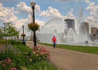
Hiking at Deeds Point in Dayton
Bill Franz
Supervisor: John Smilek
•
48.46 Total Miles / 48.46 Off Road Miles (100.0%)
Map Publication Date: November 2015
Along major rivers, on canal towpaths, along railroad tracks, under two Interstate Highways and near a monument commemorating the Wright Brothers' flying fields, the Troy Section of the Buckeye Trail offers hikers a glimpse into the evolution of transportation in Ohio. It follows in close proximity to the Great Miami River, using the same basic trail the Shawnee and Miami Indians blazed to their ancient hunting grounds in Kentucky. This trail was later used by immigrants settling the Northwest Territory from Cincinnati and eventually by the Ohio Canal Commission, which began construction of the Miami & Erie Canal in 1826. The BT starts in Fairborn Ohio and travels west running juxtapose to Wright‐Patterson Air Force Base, the largest single source employer in Ohio with over 30,000 positions in high tech logistics, test and research facilities and a squadron of C‐17 transport aircraft. The trail counties on the northern edge of the Wright State University campus. As you leave the campus you come to a short side hike that will take you up a bluff to the Wright Brothers Memorial and the view of Huffman Prairie Flying Fields where the Brothers perfected controlled flight. As you finally leave the Base area, you will view the National Museum of the United States Air Force. A museum with an incredible display of aircraft and aviation and has free admission. The Buckeye Trail continues down the Huffman Dam, one of five dams built 100 years ago to control the rivers in the Miami Valley after the devastating flood of 1913. The trail continues along the Mad River that flows into the Great Miami River. Near Point 4 on the Troy Section Map is the Eastwood MetroPark. In the summer of 2021, the Park became home to one of three new primitive campsites, all within a few steps of the BT, open to the public by Dayton MetroParks. Hikers and backpackers can register for these campsites at https://www.metroparks.org/things-to-do/camping/. Once on this page, scroll down and look on the right side of the website and you will find trailside camping with links to Eastwood, Island and Taylorsville MetroParks. The campsites are open all year round with a small fee. The sites are first come first serve with only one person/group allowed to camp each day. All the information you need to register is on the website. As you cross the bridge from Island to Triangle Park, look to the west at the baseball field. If you are a fan of professional football, you must find the historic marker just outside the left field fence. This marks the location, confirmed by the National Football League, of the former football field that hosted the first professional football game ever played. It took place between the Dayton Tringles, who won the game 14-0, and Columbus Panhandles on Oct 3, 1920! As part of an 8-mile stretch of the Great Miami River Recreational Trail (GMRRT), the BT follows the Great Miami River, under I-70 and enters the Taylorsville Reserve MetroPark. Just before you hike up the Taylorsville Dam, the second of the three Dayton area dams, you will ascend/descend on the BT, you will find the third Dayton MetroPark campsite on the west side of the trail, with facilities close by on the east side. The BT continues to follow the GMRRT through Tipp City, Troy, to Piqua. The BT transitions to the Rivers Edge Trail in the city of Piqua, Point 17, and travels north of Piqua to SR 66 where the Troy Section ends.


Trail Alerts
- (4/11/2024) Troy Section Supervisor John Smilek reports that the bridge over the Great Miami River on West Peterson Rd, Pt 16, has been demolished and will be rebuilt. The GMRTT/BT is not affected by the construction, but it is only feet away. Be award of large earth construction equipment in the area. There is still parking at the Ferrington Reserve, but hikers wishing to park there must cross the Great Miami on bridges south in Troy or north in Piqua then enter the parking area from the east on W Peterson Rd.
Map Updates
- (4/11/2024) John Smilek, Troy Section Supervisor, provided this update to the November 2015 edition of the Troy Section map:
At Pt 10 Tadmore – a Ghost Town, the Section map states, “After .26 mi at “Trail Closed” sign, turn NW across the canal prism, ascend a few feet to rejoin GMRRT (150’) and head north.” These directions are correct except the Trail Closed sign is gone and there is a tall fence made of boards blocking the trail. Just beyond this point is a dangerous sink hole. DO NOT enter. Follow the directions of the map and turn NW across the canal prism for 150’ and rejoin the GMRRT. New blazes have been added in both clockwise and counter clockwise hiking directions to show the trail for the 150’ between the former towpath trail and the GMRRT. - (3/31/2023) Five Rivers MetroParks have updated both their camping locations and procedures since the November 2015 Troy Section map was printed.
This announcement contains two items:
First, Five Rivers MetroParks phased out the campsites shown on the Nov 2015 edition of the Troy Section Map. Please make the following change on the map. Under the heading, “CAMPING ALONG THE TRAIL,” delete the entire second paragraph. And ignore the campsite symbols located close to Points 9 and 11 on the map.
Second, Five Rivers MetroParks have established three new primitive camping sites along the BT. Information about the location and process to reserve the campsites can be found on the MetroParks web page. Once on the web page, scroll about half way down and look on the right side of the page to find the title, “Camp in these MetroParks”. Under this title you will see three MetroParks that have new primitive campsites. They are titled: Island, Eastwood and Taylorsville Parks. The Island Park campsite is open 1 Apr-31 Oct. Eastwood and Taylorsville campsites are open all year. Click on the name of the park and it will take you to a link with info about the campsites including maps, pictures, parking and capacity. The site also has a link to register for the campsites which can be done online.
If you wish to mark the campsites on your Section map, Eastwood is about ½ mile east of Pt 4 (you have to climb up a small levee along the Mad River to find it), Island is at Pt 6, and Taylorsville is just west of Pt 9. All three have signs designating the camping area and are within 100 ft of the BT. - (3/28/2023) Troy Section Update
This trail change affects both the Troy and St Mary's sections. The Troy Section now ends at a new location for Point 18 at the junction of Hardin Rd and SR 66. St Mary's Point 1 begins at the same junction of Hardin Rd and SR 66. The former Troy Points 19, 20, and 21 have been moved from Troy to become the new Points 2, 3, and 4 in St Marys respectively. The result of this change is that the Troy Section now is 48.46 mi. The following table shows the new mileages and the updated description from Point 17 to Point 18.CW CCW Pt 0.0
S48.46
E1 E Dayton Ave at S Central Ave 4.5
N43.96
E2 Wright Brothers’ Huffman Prairie Bikeway at Memorial Rd 6.2
W42.26
E3 MRRT across Springfield St from Entrance to National Museum of United States Air Force 8.3
S40.16
N4 SW Corner of Eastwood MetroPark at MRRT Coordinates: [39.779633, -84.139192] 11.3
N37.16
S5 Deeds Point MetroPark (FRMP) 12.3
NW36.16
S6 GMRRT near Restrooms in Island MetroPark 17.7
N30.76
S7 GMRRT at Rip Rap Rd near End of Great Miami R Bridge [39.827517N, 84.165167W] 19.8
NW28.66
SW8 Three-Way Trail Junction near Little York Rd and Rip Rap Rd 21.4
N27.06
S9 GMRRT at Stairs to Trailhead (P, Pr, PS, PT) 23.4
N25.06
S10 Tadmor – a Ghost Town 24.9
NW23.56
E11 Trail Culvert beneath Old Springfield Rd (C8) at its Intersection with Canal Rd (T107) (P) 28.4
W20.06
E12 GMRRT near Kiosk in Canal Lock Park 33.7
SE14.76
E13 GMRRT at Small Trailhead off Dye Mill Rd (P) 36.2
SW12.26
SE14 GMRRT at Adams St Bridge near City Park 39.9
N8.56
W15 BT Marker Post on GMRRT (P) 42.3
N6.16
W16 GMRRT at W Peterson Rd (C31, P, Pr) 45.3
W3.16
E17 The Linear Trail at S Main St
Historic downtown Piqua lies in almost all directions from here. The 5-block area around here was settled primarily by German immigrants who came up the Canal from Cincinnati. Lock 9 Park is just N of the RR bridge. The park (PT, W) features historic photos mounted on attractive brick wall. A plaque indicates that the lock was built in 1837 to connect Piqua with Cincinnati (1837) and Toledo (1845) by way of the Miami-Erie Canal. It was important to the development of Piqua. Water power from this lock powered industrial development nearby for products as diverse as flour, flannel and flax seed. The lock remained in use until the great flood of 1913. GMRRT goes north through Lock 9 Park along Great Miami R first and later Miami Erie Canal Towpath to Swift Run Lake (Pt 18).
Go W across S Main St on The Linear Trail. Across College St (0.5 mi), ascend to join former RR grade. After 375 ft at trail junction, take the right hand trail to join River's Edge Trail. In .15 mi pass French Park (P,Pr) on right and then turn right (NW) with River's Edge Trail to High St (0.22 mi). Continue across High St through wooded area past Franz Pond, across Park Ave (0.4 mi), beside hydraulic canal, past Echo Lake, above Fountain Park (P, Pr,PT, PS) and across Ziegler Rd (1.1 mi). After crossing modern spillway from Swift Run Lake (0.1 mi), reach trail and footpath junction (.36 mi). (P) on right. Continue on footpath 0.26 mi along levee, across two older spillways to SR 66.48.46
NE0.0
SW18 SR 66 at Hardin Rd (C110) (P)
This ends the Troy Section - (7/23/16) Troy Section Edition of November 2015
The title for Point 5 should read "Deeds Point MetroPark (FRMP)".
Section Blogs
- (11/6/23) Troy Section Blog - Provided by Victoria Livingston, BTA hiker. Follow the Buckeye Trail along the Great Miami and examine history: remnants of locks and a canal boat, Tipp Roller Mill, the ghost town of Tadmore, and a spooky graveyard from the 1800s. Follow Victoria and her husband Dave along the Great Miami Canal - History, Whimsy, and Graveyard