
Delphos Section
- Overview
- Akron
- Bedford
- Belle Valley
- Bowerston
- Burton
- Caesar Creek
- Defiance
- Delphos
- Loveland
- Massillon
- Medina
- Mogadore
- New Straitsville
- Norwalk
- Old Man's Cave
- Pemberville
- Road Fork
- St. Marys
- Scioto Trail
- Shawnee
- Sinking Spring
- Stockport
- Troy
- West Union
- Whipple
- Williamsburg

Trail Description
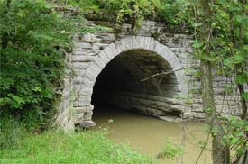
Little Flat Rock Creek Aquaduct near Pt 23
Sam Bonifas
Supervisor: David Harris
•
46.5 Total Miles / 22.7 Off Road Miles (48.8%)
Map Publication Date: September 2016
The Buckeye Trail starts this section on the towpath of the Miami-Erie Canal, between the old canal and CR-66A. Shortly, you will pass through Deep Cut Park, a 6,600 foot long, 50 foot deep cut made entirely by hand. Laborers were paid 30 cents per day plus a jigger of whiskey. The trail continues on the towpath through the town of Spencerville and on to Delphos. Lock 24N is located at Stadium Park in Delphos near Pt 8. Beyond Delphos, the trail generally follows the route of the canal through the Auglaize River valley. Loramie Summit is the high point of the canal between Cincinnati and Lake Erie. At the north end of the Loramie Summit is the town of New Bremen, where Lock 1N is located. This portion of the Miami Extension Canal, was completed in 1845. It later was re-named to become the Miami and Erie Canal.
Much of the northern half of the section follows county and township roads, ending in the town of Junction.
On Sept. 21, 1812, Col. William Jennings, with his regiment of Kentucky riflemen, was ordered by Gen. W. H. Harrison to cut a road from Fort Barbee at St. Marys to a point midway between that place and Defiance, and there establish a fort. The post was completed on this site in October, 1812, and named in honor of its builder.
The road begun by Col. Jennings was later extended to Fort Winchester (Defiance, OH) by Col. Poague, builder of Fort Amanda. The Auglaize River Valley then became a major supply artery for Harrison's army, operating to the Northwest. By boat and wagon in the summer and by sled in winter, troops and large quantities of army stores were moved through here to the scenes of the major actions.


Trail Alerts
- There are no Trail Alerts in Delphos at this time.
Map Updates
- (3/21/2023) Delphos Map Edition of September 2016
This was a trail alert dated 6/23/2020, but it is now a permanet trail change. It is necessary because a landowner who owns property along the established route of the trail claims rights that the Association does not believe that he has. As a result, the trail has left the route along the canal that users have enjoyed for several years. The trail has been returned to public roads.
The area affected is between Pt 20 and Pt 21 of the Delphos Section Edition of September 2016. The details of the detour are given below. The description gives details point to point rather than only for the trail change.CW CCW Pt Description 35.9
N10.3
SE20 Miami Erie Canal Towpath at Road 187
Turn N onto Road 187; cross the prism of the Miami Erie Canal. Continue N on Road 187. After 0.45 mi, reach an extended intersection with Road 82. Jog E on Road 82 for 100’; turn N onto Road 187. After 1.0 mi, cross SR 613 and also an active RR. At the end of Road 187 (1.2 mi), go W on Road 171.39.3 6.9 21 Site of Fort Brown (P)
Except for a small mileage adjustment, the rest of the text on your map is correct. Reduce the CCW distance S of Pt 20 by 0.3 mi. Similarly, reduce all CW distance N of Pt 21 by 0.3 mi. - (3/20/2022) David Harris, Delphos Section Supervisor, reports that due to a property liability dispute, the Delphos Section has a trail reroute to avoid a pasture that previously had stiles to get over fences. Those stiles were removed. The new reroute begins 2.1 miles north of Pt. 22, crossing a bridge over the canal on the right .5 miles north of Vaill's Lock and follows on road, Rd 163, north for .3 miles to the intersection with Rd 156 where it rejoins the original trail 2.4 miles north of Pt. 22.
The reroute is blazed with blue blazes. - (7/11/2020) This change is very pleasant. On July 9, 2020, the Johnny Appleseed Metro Park District, which manages the Miami Erie State Trail (MEST) between Spencerville and Delphos, opened a new parking facility just S of Pt 6 in the Delphos Section. The facility is named the Robert K Antibus Trail Access parking in honor of a Park District Commissioner who has served 27 years.
There is no change in distance, just an added convenience along the way if you have need of it. The points affected are shown below.
CW CCW Pt Description 6.2
N40.3
S5. MEST at SR 81
Continue N on MEST past the site of Lock 17 (0.1 mi). About 300’ S of Zion Church Rd, the only crossroad on this stretch of trail, pass an access trail that leads into a large, paved parking area. This parking is provided by the Johnny Appleseed Metro Park District. The area is accessible by road from that small stretch of Zion Church Rd that goes N-S just N of here.8.1
N38.3
S6. MEST at Zion Church Rd (T-27) in Southworth - (10/20/16) A revised map of the Delphos Section has now been published.
- (8/22/16) A revised map of the Delphos Section will issue in September 2016. The material below provides information from which you can update your earlier editions of December 2008 and April 2014.
The most exciting new information is that the number of available camping locations within this section has increased from none in 2008, two in 2014, to five in the newest edition. See “Camping Along the Trail” at the bottom of this map change. Only the early paragraphs have changed. The last paragraph contains nothing new and has been omitted here.
The Edition of 2008 announced that the Buckeye Trail Crew completed a relocation of the trail through the Ottoville Quarry Wilderness Area north of Ottoville. This relocation reduced the overall length of the Delphos Section by 0.3 miles and added 0.8 mi of trail off road. The Edition of September 2016 includes both losses and gains of off-road trail. The distance of trail off road is now 22.6 miles which is a slight loss in absolute miles off road since 2014. However, since the total distance in the section has increased to 46.5 miles, the fraction of trail off road has decreased to 48.5%.
Most of the number and placement of the section points have remained the same. However, Point 22 was moved east to Charloe since the desired trail route across Blue Creek along the towpath will not be achieved in the near future. New accumulative distances are given below, along with the point numbers and enough of the name of the location to identify the point. In addition, Where the text in the new edition is significantly different from either earlier edition, it too has been entered. Note: some time ago because of complaints, we began to use miles in the text to express distance between points of interest except for distances less than 0.1 mile. Since this difference is rather trivial, the new text is shown below only when the former text is incorrect.CW CCW Pt Description 0.0 46.5 1 Methodist Church on SR 197 in Kossuth 2.1 44.4 2 Towpath at Deep Cut Rd (C226) 3.4 43.1 3 MEST at Kolter Rd (C35)
Note that the grocery in downtown Spencerville that was described in the Edition of 2008 is closed.4.5 42.0 4 Towpath at North St in Spencerville 6.2 40.3 5 Towpath at SR 81 (Allentown Rd) 8.1 38.0 6 MEST at Zion Church Rd (T27) in Southworth 13.3 32.2 7 MEST at Cleveland St in Delphos 14.8 31.7 8 Towpath at Pohlman Rd 15.6 30.9 9 Road U20 at SR 190 17.6 28.9 10 Road U20 at Road 23T 19.8 26.7 11 Road 23T at SR 190 20.6 25.9 12 N Water St (SR 189/SR 190) at Fourth St 23.0 23.5 13 Road R23 at Road 24Q 24.6
N21.5
E14 Third St (SR 189) at W Canal St (US 224) in Ottoville
Facilities:(MM, P, PO: 45876, R, W)
Go N on W Canal St. After 2 blocks at Main St, US 224 turns E. Keep N past end of W Canal St (300') to pond. Follow trail around W edge of said pond past trail (300') that leads to a small parking area off Church St near the Little Auglaize R. After 250’, turn N onto the towpath of the Miami and Erie Canal. Leave the towpath only briefly to join a service road on levee where a channelization project along the river has impinged on former canal.25.7
N20.4
S15 Miami and Erie Towpath at Rd P and Rd 25M
Head N on Road 25M, which is a hair W of the canal towpath, past Road O25 (0.5 mi, exits W), past Road O (0.5 mi, exits E), past Road N24 (0.5 mi, exits E), and across Road N (0.5 mi).28.7
N17.4
S16 Road 25M at Road M
In both earlier editions near the end of this description, the names for Road 203 and Road 1010 are switched. In addition, Road 32 is mentioned but is no longer easily seen. Replace with the following text: The Putnam/Paulding Cty Line crosses this intersection. The roads that comprise the intersection are identified differently in each county. On its S side, signs identify Road 25M at Road M (Putnam Cty) and on its N side, as Road 203 at Road 12 (Paulding Cty). Continue N on Road 203, the continuation of Road 25M, past Road 266 (0.5 mi, exits E), past Road 18 (0.4 mi, exits NE) and past Road 1010 (1.1 mi, exits W). Head NE on Road 203 that parallels the over-grown canal prism. After 0.24 mi, jog W on SR 114.
31.0 15.5 17 SR 114 at SR 66 in Mandale (No Services) 32.5 14.0 18 Road 48 at Miami and Erie Canal Heel path
No Parking In this narrow, wooded strip of land is the Miami and Erie Canal. Because of a land dispute, BTA has lost access to a trail that the Buckeye Trail Crew built on the heelpath. Hopefully, the loss is only temporary. Continue W on Road 48 past Road 199 (40', exits SE). At the next intersection, turn N on Road 197. After 0.9 mi at a wooded strip, reach remnants of canal. Hipp's Timberville Lock 31 (C) is located 0.17 mi SE on side trail on heelpath. Turn NW onto former heelpath and soon cross Road 60 (350'). ). Continue N across a bridge (150') and enter narrow piece of woods. By now, you will see easily that you are following the prism through woods and field.35.3 11.2 19 Miami and Erie Canal Towpath at Road 72 35.9
N10.6
SE20 Miami and Erie Canal Towpath at Road 187
Turn N onto Road 187, crossing the filled canal prism to the heelpath of canal (100’). Turn NW onto footpath. After 0.5 mi, reach Road 82. Follow Road 82 E. After 0.24 mi, enter an extended intersection with Road 187 that comes from the S. After 100' as Road 82 continues E, turn N onto Road 187. Continue N across SR 613 (1.0 mi) across RR. At the end of Road 187 (1.1 mi), go W on Road 171.39.6 6.9 21 Site of Fort Brown (P)
Delete the last 2 sentences from the text because Point 22 has been moved to Charloe.41.5
W5
S22 Road 171 at Road 138 in Charloe
Facilities: City Park, MM, PS, W. As Road 171 continues N, turn W onto Road 138. After 0.5 mi, exit Road 138. Turn N onto Road 163. The broad low area just E of the road in agricultural fields are the remains of the Miami and Erie Canal. After 0.7 mi near a wood’s edge, exit Road 163 E to towpath (100') and turn N. After 0.3 mi, leave woods. Follow W edge of tilled fields N across Road 146 (0.35 mi) and beyond. After 0.3 mi, leave edge of tilled field briefly for woods at Viall's Lock 32 (C). At end of tilled fields (0.45 mi), cross fence on stile. Continue to follow towpath generally N in both open and wooded pasture with fences and stiles. Cross Road 156 near its intersection with Road 163. Continue N through field and across driveway past shed into woods where the towpath is followed easily. Near creek, descend NW across canal prism to Road 163. Across Flat Rock Creek, leave Road 163 and ascend NE to towpath. Continue N in woods for 0.24 mi. Exit woods and continue N on W edge of tilled field across Road 170 (350') and beyond. After 0.7 mi, enter woods on towpath that continues N past a canal mile marker (200'). After 300’, cross canal prism NW on boardwalk.46.0
N0.5
SE23 Intersection of Road 163 and Road 1023
Join Road 163 heading N. Immediately N of Little Flat Rock Creek (0.2 mi), exit Road 163 E onto footpath that will climb beside the beautiful arched stone culvert that conducts the creek beneath the canal prism.
At the prism, follow heelpath briefly before crossing to the towpath and turning N. After 0.3 mi, jog W on Road 111 across the filled canal prism. Head N on the heelpath to a display (450') with parking that memorializes the junction of the Miami & Erie and the Wabash & Erie Canals. The two remain joined from here NE to their final junction with the Maumee R near Toledo. This memorial is just a few feet S of SR 111.46.5 0.0 24 SR 111 at Road 111 and Road 153 in Junction
CAMPING ALONG THE TRAIL
The location of all camping facilities, known to BTA, that are within reasonable walking distance of the trail, are shown on the Section Map and listed below. The campsites listed under 2, 3, 4 and 5 are not serviced. Please carry out all trash, including any that you may find there, from these 4 sites.- No-trace camping is permitted in the park just N of North St near Pt 4 with permission. Call the Spencerville Police, 419-647-4141.
- A shelter is located near the site of Lock 18 which is 0.35 mi N of Pt 6. Installed by Buckeye Trail Crew during 2015, the shelter can be seen 136' NE across prism.
- A primitive campsite with no facilities is located just north of Pt 8 where the towpath ends at Jennings Creek.
- A primitive campsite with no facilities is available at Hipp’s Lock which is located off the trail between Pt 18 and Pt 19. The site can only be reached from Road 197. See Pt 18 text.
- A primitive campsite with no facilities is available at Viall’s Lock which is located between Pt 22 and Pt 23 off Road 163 in Paulding County.
Section Blogs
- (8/3/23) Delphos Section Blog - Provided by Victoria Livingston, BTA hiker. Join Victoria, her husband Dave, and fellow hiker Pat on the trail from Fort Brown at Point 21 to 24 Point, 7.5 mi. They found strange artwork on the BT including: Sasquatch, Heron, and Hula Dancer. Follow their adventure here on the BT .
- (8/3/23) Delphos Section Blog - Provided by Victoria Livingston, BTA hiker. Join Victoria, her husband Dave, and fellow hiker Pat as they hike the BT from Delphos Point 12 Fort Jennings to Point 17, Mandale 11.3 mi. On this hike they found gratitude to veterans and kindness to strangers. Follow their adventure here on the BT .