
Burton Section
- Overview
- Akron
- Bedford
- Belle Valley
- Bowerston
- Burton
- Caesar Creek
- Defiance
- Delphos
- Loveland
- Massillon
- Medina
- Mogadore
- New Straitsville
- Norwalk
- Old Man's Cave
- Pemberville
- Road Fork
- St. Marys
- Scioto Trail
- Shawnee
- Sinking Spring
- Stockport
- Troy
- West Union
- Whipple
- Williamsburg

Trail Description
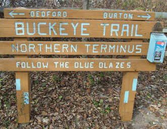
Northern Terminus
Barb Crompton
Supervisor: Tim Murphy
• 440-728-1662
56.9 Total Miles / 30.5 Off Road Miles (53.6%)
Map Publication Date: March 2018
The Burton Section begins at the northern terminus of the Buckeye Trail, in Headlands Beach State Park on the shores of Lake Erie. BT heads south away from Lake Erie on streets through Grand River into Painesville. BT passes The Rider Inn, waypoint on Underground Railroad and joins Lake County Metroparks Greenway. Trail climbs steadily up low Appalachian escarpment and visits Girdled Road Reservation. After crossing into Geauga County, the trail passes through Big Creek Park, where camping is permitted by reservation. The trail continues south approaching the headwaters of the Cuyahoga River, continuing through the village square of Burton. Century Village on Burton Square is a site of various festivals highlighted by the annual Apple Butter Festival every autumn. South of Burton, the trail passes Hiram Rapids on the Cuyahoga River before passing into the Mogadore Section.


Trail Alerts
- There are no trail alerts at this time.
Map Updates
- (6/2/2023) This material updates the Burton Map, Edition of March 2018. It is needed because a major effort is underway to move the Buckeye Trail off the busy Rapids Rd.
To correct your text in the map edition March 2018, at Point 23 about halfway in the paragraph, replace the sentences with the following:
As road curves E, (0.13mi) continue S on unmarked trace past the village waste water facility (0.2mi). Turn right (W) on to Akron Watershed access road. In 0.2mi turn left (S) on trail and follow to old trail (100'). Turn right (SW) and in 365' reach NE edge of a farmed field. Continue W along edge of farmed field. Follow the remainder of the Point 23 description.
- (12/15/16)Thanks to one of our loyal supporters for reporting an error within the text under Point 25 to the Map Team. While the map clearly shows the trail turning W at the intersection between Ryder Road and Pioneer Trail, ruefully, the text asks hikers to turn E. In addition, a member of the Map Team noticed that the length of Ryder Road was only 5200’ rather than the 6200’ declared in the text. As if that were not enough, another member of the Map Team could find no evidence for either a motel or a restaurant in Hiram at this time. And taking into account all of the trail changes installed by the Burton Section Supervisors described below, please substitute these details for those shown under Point 25 in your Burton Edition of April 2011.
CW CCW Pt 52.9
E4.5
N25 Alpha Rd (T277) at SR 82
BT turns E onto SR-82 to Ryder Rd (1100', T-268, exits S). SR-82 continues into Hiram (PO: 44234), the home of Hiram College. BT turns S onto Ryder Rd past Fairview Cemetery. In 5200', Ryder Rd ends. BT turns W onto Pioneer Trail (5200', C-254) past Asbury Rd (1900', T-223, exits S).54.6
S2.8
E26 Pioneer Trail (C254) at Service Drive into Camp Asbury
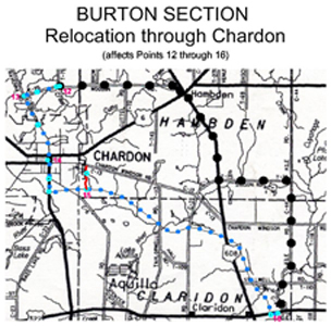
- (10/21/16)Section Co-Supervisors Jan Geho and Tim Murphy have completed a major reroute of the trail north of Chardon. The reroute is 6.9 miles long. Less than 0.2 miles is on road and the reroute removes over a mile of trail from road. The new trail lies within a segment that lies between Point 12, Robinson Road at Woodin Road, and Point 14, North St at Center St on Chardon Square. Point 13, Woodin Road at Old SR 44, is no longer on the trail route.
The points refer to the map update of 9/15/16 below. The map update of 9/23/16 remains current. At this time, the author of these updates does not have accurate distance data from the changes described in the 9/23/16 update. When data become available, a complete update will replace the table shown in the 9/15/16 update.
In the meantime, an abbreviated table is presented that reflects the route change between Points 12 and 14. In this table, points designated by letters will probably become numbered points in the next map edition.
In addition, since the author was advised that the blazed route on the Square is not the same as that described in the Burton Map Edition of April 2011, he took this opportunity to update the revised route here. This update has been extended to include Point 15, South St at Maple Highlands Trail.
The table below shows the details:
CW CCW Pt 0.0
E8.5
N12 Robinson Rd at Woodin Rd
Turn W onto Woodin Rd that crosses Big Creek and, after 350', passes Woodin Park (P).0.5
N8.0
EA Big Creek Park (Geauga Park District)
Turn N into parking area (P, Pr). Continue past kiosk (200') onto the Creek Bridle Trail that meanders and undulates N and W down the valley of Big Creek. Wooden posts along the route exhibit the familiar BT blue markers. After 2.1 mi, go W through an entrance to a parking area (Pr) from the Bridle Trail.2.7
NW5.8
NEB Exit from Big Creek Park Parking Area onto Ravenna Rd (P, Pr)
Turn N onto Ravenna Rd. After 0.16 mi, turn W at an entrance to large parking area for the Big Creek Spur which provides access to the Maple Highlands Trail. Continue through parking area and, after 450’, past privy and through an entrance onto the Big Creek Spur itself.3.7
SW4.8
SEC 3-Way All Purpose Trail Junction
Here, Big Creek Spur joins the Maple Highlands Trail coming from the N on a former B&O rail line. Although the railroad right-of-way continues S, the trail continues generally W. After 014 mi near SR 44, the trail turns generally S, paralleling the east side of SR 44, across Hosford Rd (0.5 mi). Shortly after passing beneath a major electric utility corridor (1.2 mi), the trail turns E. It now parallels the utility corridor. After 0.45 mi, the trail rejoins the firmer RR right-of-way.7.0
E1.5
ND Sidewalk on North Side of 5th Ave
Leave the Maple Highlands Trail here at sidewalk on the N side of Fifth Ave in Chardon. Go E past Washington St (0.13 mi). After 0.26 mi at North St, cross North St to sidewalk on E side of street and turn S.7.7 0.8 14 North St at Center St on Chardon Square
Note: this title expresses the content of the edition of April 2011. It will be changed in a newer edition to that below. The problem is that the description of the intersection was shortened to make things fit. The intersection is really a 3-way intersection of North St, Center St and N Hambden St. In addition, the trail specifically follows the sidewalk on the E side of North St.7.7
S0.8
N14 Sidewalks on NE Corner of North St at N Hambden St on Chardon Square
Chardon is the center of Ohio's maple sugar industry and home to an annual Maple Festival each spring. Other amenities: PO is W on Center St/ SR 44; L, R, M are W on Water Street/US6; the public library is on the E side of square.
BTA suggests a route that works with Chardon's heavy traffic pattern. Following the blue blazes, continue S across N Hambden St/Center St on crosswalk towards the Geauga County Courthouse (1869). After 85', turn E on sidewalk on S side of N Hambden St. After 100', turn S on lawn towards asphalt strip between Courthouse parking and E Park St parking. Follow strip S across both the entrance to Courthouse parking from E Park St (250') and the crosswalk on the E end of Short Court St. Several R may be reached just W on the far side of Main St. Continue S along edge of parking along E Park St. After 450' at sidewalk on the N side of S Hambden St, go E across E Park St. Cross S Hambden St and turn W. Join the sidewalk on the E side of South St and turn S.8.5
E0.0
N15 Sidewalk on E Side of South St at Maple Highlands Trail - (9/23/16)This information updates the April 2011 Burton map. Co-Section Supervisors Jan Geho and Tim Murphy have made additional reroutes to the trail, as follows:
1. Point 6, The Greenway at Bikeway Access to the Stone School Trailhead
Continue south on The Greenway a short distance. With a highway overpass (SR 608) in view ahead, turn east (left) onto an asphalt path w/drinking fountain. Continue to follow infrequent blue blazes through the Lake Metroparks Environmental Learning Center. Note that all intersections are clearly marked. The trail descends, sometimes steeply enough to use steps, to Jordan Creek where it joins an asphalted path. Turn right and ascend. Shortly, turn right onto Alexander Road. After 450’, rejoin the current route at SR 608. Turn east (left) and continue to Point 7, SR 608 at Williams Road.
2. Point 9, Lake Metroparks Parking off Girdled Road
Follow the existing trail generally south from this parking area. Shortly after crossing a sturdy bridge across Ayles Creek, reach a 3-way trail intersection. Join the Oak Leaf Trail and continue straight ahead. At a second intersection with a large swinging bridge in view, leave the Oak Leaf Trail and turn right (west) across Big Creek on the swinging bridge. Shortly, ascend steeply to Skok Meadow and the Skok Meadow Trail. Continue west (straight ahead) to the Skok Meadow Parking Area (Pr, PS, PT). Follow Skok Meadow Trail south past two ponds.
At the south end of the second pond, the Skok Meadow Trail jogs east. Turn W towards a prominent red barn. This barn is the oldest known barn within Lake County which stands on its original foundation. It was built by Hosea Brown in 1817. Continue west past a small parking area (overflow from Skok Meadow Parking Area) to SR 608. Turn south (left) onto SR 608. After 0.35 mi as SR 608 begins serious, curvy descent, rejoin the existing BT route. Turn SW (right) onto Winchell Road.
3. Point 10. Note: the trail no longer reaches Point 10 on the banks of Big Creek, which is defined as BT at Concord Hamden Road (SR 608). - (9/15/16)This update to the Burton Section updates the distances throughout the Section as well as the trail description between Points 19 and 20 to conform to the trail reality. Co-Section Supervisors Jan Geho and Tim Murphy have moved the trail onto the Maple Highlands Trail between Point 19, Headwaters Park Drive at SR 608, and the intersection of Maple Highlands Trail with Durkee Rd. This action reduced the length of the Burton Section by 0.4 miles and overall increased the amount of trail off road by 0.3 miles. The new fraction of trail off road in the Burton Section is 42.0%.
CW CCW Pt 0.0
SE52.2
W1 Headlands Beach State Park at Entrance to Headlands Dunes State Nature Preserve 0.6
E51.6
NE2 Ellison Rd at Headlands Rd (C518) 2.4
S49.8
NW3 Richmond St at Newell St (C335) 4.0
NE48.2
N4 Newell St at Mentor Ave (US 20) 4.9
SE47.3
SW5 W Washington St at The Greenway 8.6
N43.6
NW6 The Greenway at Bikeway Access to The Stone School Trailhead 9.8
NE42.4
NW7 SR 608 at Williams Rd 10.7
S41.5
SW8 Williams Rd at Cascade Rd 12.5
S39.7
W9 LCMP Parking off Girdled Rd 14.5
NW37.7
N10 BT at Concord-Hambden Rd (SR608) 16.8
S35.4
N11 Robinson Rd at Pearl Rd 19.1
E33.1
N12 Robinson Rd at Woodin Rd 20.0
S32.2
E13 Woodin Rd at Ravenna Rd 21.5
S30.7
N14 North St at Center St on Chardon Square 22.3
E29.9
N15 South St at Maple Highlands Trail 23.1
E29.1
W16 Mountain Run Station Trailhead 28.6
E23.6
N17 Maple Highlands Trail at US 322) 28.7
S23.5
W18 North Gate to Headwaters Park 31.1
S21.1
NE19 Headwaters Park Drive at SR 608
BT joins Maple Highlands Trail that heads S across golf course (public R in clubhouse). After 1600', BT leaves Maple Highlands Trail that continues S. Climb W on Durkee Rd. At end of Durkee Rd, BT turns S onto Hale Rd along a high ridge past Butternut Rd (1300', C21, exits W).33.5
W18.7
N20 Hale Rd at Burton-Windsor Rd 35.2
S17.0
N21 Burton Square 39.4
S12.8
N22 Rapids Rd at entrance to Eldon Russell Park (GPD) 42.0
S10.2
N23 Rapids Rd at US 422 45.0
SE7.2
N24 Pope Rd (C278) at Winchell Rd (C264) 47.7
E4.5
N25 Alpha Rd (T277) at SR 82 49.4
S2.8
E26 Pioneer Trail (C254) at Service Drive into Camp Asbury 52.2
W0.0
E27 Headwaters Trail at Asbury Rd (T223)
- (5/19/11) A newly revised Burton Section Map was issued about May 1, 2011. If you are using the older edition, dated February 2006, this alert is intended to keep your map more or less up to date; i.e.- only trail changes are included. Changes to grammar and some local information are not necessarily included. Accompanying maps on the web site show the changes where the February 2006 Edition is totally inadequate. The length of this Section is now 52.6 miles long rather than the former 52.5 miles. This alert does not apply to the May 2011 edition.
The trail no longer goes through Camp Klein. Instead, it uses the new Stone School Trailhead. See details at Points 5 and 6 below.
| CW | CCW | Pt | |
|---|---|---|---|
| 4.9 SE |
47.7 SW |
5 | W Washington St at The Greenway BT joins Lake County Metroparks (LCMP) Greenway Corridor (The Greenway) heading SE, following mostly along former Baltimore & Ohio RR to Old Stone School Trailhead (Pt 6). Since parking is discouraged except at trailheads, crossing details have been minimized. However, after 2100' at W Walnut Ave, The Greenway leaves RR for about 1/2 mile. Follow signs for Greenway NE on W Walnut Ave for 910', turn S onto Liberty St for 1200', and turn W onto Frederic St for 680', rejoining RR grade. The Greenway continues SE, after 2900' passing Trailhead (TH) at Johnny Cake Ridge Rd (P, R), continuing SE. Just after leaving the I 90 overpass, The Greenway reaches a side-trail to Chair Factory Falls (PT). Side-trail leads E after 1500' to lovely waterfall w/benches in deep ravine, conducting Gordon Creek. Continuing SE 130', The Greenway passes Pr on W. |
| 8.6 W |
44.0 NW |
6 | The Greenway at Trail to The Stone School Trailhead BT leaves The Greenway, going W across bridge on improved trail, after 380' entering the TH (P), passing Concord Twp Old Stone Schoolhouse, after 180' turning S onto Ravenna Rd, after 530' joining Concord-Hambden Rd (SR 608), heading SE past ball field w/Pr. |
- (5/19/11) The phone number shown at Point 9 for the desk where reservations for camping may be made should read 440-358-7275. The times for operation of the desk should read Monday through Friday, 8:30AM to 4:30PM.
- (5/19/11) Shortly after exiting Big Creek Reservation, the trail has been rerouted through Chardon in order to take advantage of the new Maple Highlands Trail that traverses the wetlands that comprise the headwaters of the Cuyahoga River. The trail now leaves the former route at Point 12 and returns to its former route at the entrance to Headwaters Park just east of Point 16 on February 2006 edition. To avoid confusion between the editions, the points along the new route are shown as "chapters" of Point 12 (For example, 12.1).
| CW | CCW | Pt | |
|---|---|---|---|
| 19.0 W |
33.6 N |
12 | Robinson Rd. at Woodin Rd. BT turns W onto Woodin Rd, crossing Big Creek, after 360' passing Woodin Road Park (P), after 2300' passing parking (Pr) for equestrian access to Big Creek Park. |
| 19.9 S |
32.7 E |
12.1 | Woodin Rd. at Ravenna Rd. At end of Woodin Rd, BT turns S onto Ravenna Rd. CAUTION: dangerous road walk. Just across Chardon City Line (3700'), BT joins sidewalk on W side of North St as Ravenna Rd is known within Chardon. |
| 21.4 S |
31.2 N |
12.2 | North St at Center St on Chardon Square Chardon is the center of Ohio's maple sugar industry and home to an annual Maple Festival each spring. West of the square, the city offers most urban amenities of interest to through hikers (G, L, M, P, PO: 44024, R). BT Circuit Hikers will find what they need here on Chardon Square. BTA suggests trail details that work with Chardon's heavy traffic pattern. BT jogs W onto Center St, after 150' crossing Center St at crosswalk on W side of Main St, heading S, passing Geauga County Courthouse (1869). After 520', there is a handy crosswalk if you wish to investigate the park on the square. BT continues S on sidewalk on W side of Main St. After 510' at SW corner of the Square, BT crosses Water St, turning E onto sidewalk on S side of Water St, after 150', crossing South St, turning S onto sidewalk along E side of South St. |
| 22.2 E |
30.4 N |
12.3 | South St at Maple Highlands Trail (MHT) Here, BT joins MHT, a paved multi-purpose trail built and managed by GPD. MHT goes through wetlands that comprise the source of the Cuyahoga R. MHT crosses several roads and streams, sometimes on covered bridges. Since parking is not permitted near any of these crossings, many location details are omitted along MHT. BT leaves South St heading E on MHT. |
| 23.1 E |
29.5 W |
12.4 | Mountain Run Station Trailhead (P, Pr, PT) A side-trail leads after 1800' to Mountain Run Station Trailhead. The Trailhead is located off Chardon Windsor Rd E of Chardon Square. BT continues E on MHT that will turn essentially S in time. |
| 28.5 E |
24.1 N |
12.5 | Maple Highlands Trail at US 322 Here, BT leaves MHT on path, heading E along S side of US 322 on lawn in front of utility substation, continuing E on gravel path as lawn ends. |
| 28.7 S |
23.9 W |
12.6 | North Gate to Headwaters Park (P, Pr, PT) Headwaters Park, owned by City of Akron and administered by Geauga Park District (GPD), comprises 926 acres lying along the W shore of East Branch (Cuyahoga R) Reservoir. The Reservoir is part of Akron's drinking water supply. The rule to stay on trail is enforced. BT turns S through gate onto service road that passes the privy after 380'. GPD has generously labeled the next two miles of service road as Buckeye Trail. Trail is shared with bicycles and horses. After 480', BT passes entrance to Eagle Trail (exits E), a foot-trail that both views reservoir and returns to BT 1800' ahead. BT continues generally S, crossing several small streams. After about 2 mi, immediately after crossing narrow strip of land between one large pool and reservoir, a small footpath leads S to small camping area, requiring reservations and administered by GPD. BT continues on service road SW past exit from camp loop (800') through gate (180'), passing one major parking area (100') and then another (1100'), finally crossing the MHT. |
- (5/19/11) The trail south of Point 19 has been moved slightly to take advantage of Veteran's Memorial Forest and Burton Headwaters Park. Note that the trail no longer turns west at Carlton St. These changes are described below.
| CW | CCW | Pt | |
|---|---|---|---|
| 35.4 S |
17.2 N |
19 | Burton Square Burton is like a New England village. Near an Amish community, it is home to the Great Geauga County Fair, Ohio's oldest and largest fair. Working sugarhouse on the square makes maple syrup in season and functions as a tourist information center and outlet for maple products. Local civic groups hold pancake breakfasts every March. Library (internet access), antique stores, R, L, P, PT Continuing S from public square on S Cheshire St, BT passes Century Village Museumf, a collection of historic buildings which hosts annual Apple Butter, Antique Power and Bluegrass/Folk Music Festivals, later passing Red Maple Inn B&B and Carlton St. After 1900' as road curves E, BT continues S on unmarked trace, passing public hunting land (Caution!), passing village waste water facility. After 1700', BT joins Memorial Drive, continuing S into Memorial Cemetery (No Parking!) w/legible stones, final resting place of early pioneers that includes Revolutionary War veterans. At W edge of cemetery, BT enters Veterans Memorial Forest, passing Buckeye Trail sign, crossing streamlet on footbridge. Bridge, sign and trail comprise an Eagle Scout project. After 1200', BT enters Burton Headwaters Park at NE corner of farmed field that feeds several resident Sand Hill Craness. BT continues W along edge of farmed field, turning past trail that leads after 2000' to Burton Twp Maintenance Barns (Pr, S), turning S past small impoundment, continuing around farmed field just above wetlands. After 3100', BT joins Rapids Rd heading SW, after 2500' crossing West Branch Cuyahoga R, after 3600' passing Pond Rd (exits W). |
Section Blogs
- There are no Blog posts at the present time.