
Bedford Section
- Overview
- Akron
- Bedford
- Belle Valley
- Bowerston
- Burton
- Caesar Creek
- Defiance
- Delphos
- Loveland
- Massillon
- Medina
- Mogadore
- New Straitsville
- Norwalk
- Old Man's Cave
- Pemberville
- Road Fork
- St. Marys
- Scioto Trail
- Shawnee
- Sinking Spring
- Stockport
- Troy
- West Union
- Whipple
- Williamsburg

Trail Description
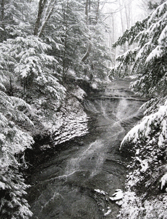
Bridal Veil Falls
Darlene Karoly
Supervisor: Bob Morecki
•
66 Total Miles / 44.4 Off Road Miles (67.3%)
Map Publication Date: April 2022
The Bedford section begins in the Brecksville Reservation, a unit of Cleveland Metro Parks(CMP), at a simple sign near a parking area marked Buckeye Trail. This point marks the beginning of both the Bedford and Akron Sections and the end of the Medina Section. Although changes to the trail continue, this junction marks the point at which the Buckeye Trail (BT) was formally completed in 1981 as a hiking trail in a loop that can be said to link the four corners of Ohio.
The Bedford Section goes generally northeast from Brecksville Reservation to Headlands Beach State Park on Lake Erie, the BT's most norther extension, where the trail meets the Burton Section. Along the way, the trail follows the Towpath Trail in Cuyahoga Valley National Park, and then trails through Bedford Reservation (CMP) and South Chagrin Reservation (CMP). Although more road walking is encountered from here on, significant intervals on footpath are found within North Chagrin Reservation (CMP), Chapin Forest Reservation, a unit of Lake Metroparks (LMP), with its view of Cleveland off in the distance, Penitentiary Glen Reservation (LMP), Mentor Lagoons Nature Preserve (City of Mentor) along bluffs above Lake Erie and Mentor Marsh State Nature Preserve where you may see nesting eagles.


Trail Alerts
- (12/19/2023)The Cuyahoga Valley National Park has announced the closure of approximately 1.5 miles of the Ohio & Erie Canal Towpath Trail north of Station Road Bridge Trailhead in Brecksville. The closure is necessary for public safety while a contractor completes Phase 1 of a riverbank stabilization project. The trail is closed on weekdays from 5:00am Mondays through 6:00pm Fridays. The closure will last from December 18, 2023 through May 3, 2024. Note, the Towpath Trail will be open on the weekends. The Buckeye Trail on the Towpath Trail is closed between Point 3 and 4 in the Bedford Section during the stated times. However, also please note that the closure also affects Point 5 because the detour bypasses Point 4 completely.
The detour is as follows:- CW:
At Point 3, Station Road Trailhead, BT crosses the Cuyahoga River on a bridge and enters Summit Cty from Cuyhaoga Cty. In 450’, BT crosses the Towpath Trail (TPT), curves to right and ascends Pine Hill Rd (no traffic allowed). At the top, follow road to metal guardrail and cross SR 82. Go E on SR 82 for 300’ and at Chaffee Rd turn left and go N 1.5mi. At Canal Rd turn left and go NW 1.3mi to Sagamore Rd. [Frazee House (just E of Point 4) is located 500' N on Canal Rd.] Turn right onto Sagamore Rd and continue on blazed BT to Point 5. - CCW:
If you are hiking CCW on the BT from Point 5 to Point 3, when you reach Sagamore Rd and Canal Rd you would turn left (SSE) and go 1.3mi on Canal Rd to Chaffee Rd. At Chaffee Rd turn right (S); go 1.5mi to SR 82; turn right (W) onto SR 82. After 300’, cross SR 82 to Pine Hill Rd (no traffic allowed) and descend into the valley. Cross the Towpath Trail and proceed to the Station Road Bridge crossing the Cuyahoga River to continue on the blazed BT to Point 3.
- CW:
Map Updates
- (2/8/2024) This map update addresses a trail change to the BT in Headlands Beach State Park between Points 33 and 34 in the Bedford Section. Recent work at the park to restore a wetland resulted in taking the BT off-road for this entire Point. The actual trail reroute only changes the length of this point 100ft which is minimal.
The new description for Point 33 is as follows: - (4/7/2020) This material updates the Bedford Map, Edition of February 2012. It is needed because the information at Pt 11 (Bridle Path Junction near Harper Ridge PA) was confusing; i.e.- poorly written. In short, the trail does not cross Hawthorn Pkwy here. Only cross the pkwy if you wish to take advantage of any of the facilities in the picnic area. To correct your text in your February 2012 edition, replace the first sentence under Pt 11 with the italicized material in the text below.
- (4/23/18)Hopkins Road in Mentor between Hendricks Rd and Plaines Rd will be closed for 6 months for highway work beginning on Friday, April 27. This location is a little S of Point 29 as shown in the Bedford Section Map Edition of February 2012. Even though Hopkins Road will reopen, the BTA is making a permanent route change to ensure safer hiking. Said change is shown below in new text added at the end of the present text written under Point 28. See below. This change will increase the length of trail in the Bedford Section by only 0.16 miles.
CW CCW Pt 55.7
N10.3
S28 Hopkins Rd at Mentor Ave (US 20)
Facilities: G to E, R to E and W.
BT continues N on Hopkins Rd past schools and cemetery. Trail follows a paved bicycle path N across Jackson St and gradually turns NW through industrial area. Shortly after crossing above SR 2 at the intersection of Hopkins Rd, Munson Rd and Market St, BT turns NE still along Hopkins Rd past Civic Center Park. In 1400' across from Pinewood Court, BT turns NW away from Hopkins Rd and descends to cross Marsh Creek in wooded area. Bikeway turns N as it comes in view of Mentor Civic Arena (P, WC) and returns to Hopkins Rd at Rosewood Lane. BT continues N along Hopkins Rd. After 0.13 mi, exit Hopkins Rd W onto Hendricks Rd. At the end of Hendricks Rd (0.35 mi), turn N onto Center St. After 0.4 mi at the intersection of Center St, Plaines Rd and Hopkins Rd, rejoin Hopkins Rd and continue N.59.0
N7.0
S29 Entrance to Veterans Park (Lake Metroparks)
Facilities: P, PS, PT, W, WC - (8/8/17)While attempting to follow the Bedford Section Edition of February 2012, hikers raised questions about the exact route of the trail through the Pinery Narrows. The text under Point 3 has been rewritten to clarify this important issue. In addition, some matter, which does not seem either important or interesting any longer, has been removed. The style remains unchanged.
If the text under any other points cause you problems, please let us know. After all, a Section Map that leaves anyone in doubt about the route of the trail is of little use at all.
CW CCW Pt 1.9
NE63.9
W3 Station Road Trailhead (P, WC)
BT crosses Cuyahoga R on bridge and enters Summit Cty from Cuyahoga Cty. After 450‘, BT turns N on Towpath Trail (TPT). Just before passing beneath an arched highway bridge (SR 82), BT diverges briefly W from the TPT to cross the headworks of a feeder canal and then passes near the old state dam. Portions of the downstream wingwalls from Lock 36 can be seen across canal beneath TPT bridge where the trails merge. BT continues on the TPT generally N through Pinery Narrows which was named after the White Pine indigenous to the narrows. A pine or two may be seen from the TPT, particularly in winter, on the valley rim above the canal. - (2/28/16) For one reason or another, an error has persisted on the Bedford Section Map for many years until Pat Hayes spotted it in February 2016. Thankfully, it apparently bothered no one since it had not been reported since at least 2001 when this portion of the trail was first established. At that time, the trail segment was described in the Burton Section!
The correction occurs towards the end of the text in the Bedford Section Point 29. In the last sentence, change "Hillcrest Ave" to "Harbor Drive." This last sentence under Point 29 should now read, "At the end of Hopkins Rd, the BT jogs E on Lake Shore Blvd (SR 283), N on Harbor Drive and then E on Harbor Drive." You guessed it! Harbor Drive heading N intersects another Harbor Drive heading E/W.
| CW | CCW | Pt | |
|---|---|---|---|
| 65.2 N |
0.8 S |
33 | Shipman Pond Parking Area (P) at Headlands Rd Cross Headlands Rd to enter Headlands Beach State Park (P, PA, PS, PT, WS, WC) on BT. In 60ft, turn right (NE) along tree line and ascend to top of hill. In 200ft at trail switchback, descend heading NW and gradually turn left (W). After 400ft, follow BT another 510ft as it curves around the restored wetland, first turning NW, then N, and finally NE. In 0.62mi, reach the Northern Terminus of the BT. |
| CW | CCW | Pt | |
|---|---|---|---|
| 38.6 N |
15.0 S |
11 | Harper Ridge PA You are here: 41.41457 N, 81.45926 W. The drive into Harper Ridge PA (no W) is just across Hawthorn Pkwy. If you prefer, a more rustic approach into the PA is just ahead at: 41.41469°N, 81.45861°W. From there, a bridle trail heads S across the pkwy into the woods. The bridle trail continues S along the E side of the Harper Ridge PA and provides easy access to the PA. BT continues E across 2 private roads . . . . This material ends here. Return to the text under Pt 11 in your present edition. |
Section Blogs
- There are no Blog posts at the present time.